The National Geologic Map Database is migrating to a new infrastructure. We apologize for any service disruptions during this process.
|
|---|


- Usage in publication:
-
- Fossil Butte Member*
- Modifications:
-
- Named
- Dominant lithology:
-
- Mudstone
- Sandstone
- Siltstone
- Limestone
- Shale
- AAPG geologic province:
-
- Green River basin
Summary:
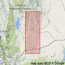
Named as a member of Green River Formation for exposures on south side of Fossil Butte and along north and east sides of Fossil Ridge, 10 mi west of Kemmerer, Lincoln Co, WY in the Greater Green River basin. Type section measured and described in SW1/4 NW1/4 sec 5, T21N, R117W. Is the most extensive member of the Green River in Fossil basin. Is 208 ft thick at type. Is 267 ft thick in valley of South Fork of Twin Creek. Consists of four units (ascending order): 1) basal light-gray, fine-grained to very fine-grained, calcareous sandstone, mudstone, and siltstone; 2) gray limestone, siltstone, and chocolate-colored shale; 3) buff-weathering laminated limy shale, paper shale, and oil shale that alternate with white to buff marlstone; and 4) ledge-forming limestone. Thin ash beds are scattered throughout unit 3. Overlies main body of Wasatch Formation, and depending on locality overlies and intertongues with sandstone tongue of Wasatch. Is overlain by Angelo Member (new) of Green River. Underlies and intertongues with mudstone tongue of Wasatch. Contains fish, insect, leaf, ray, bat, and bird fossils. Assigned an early Eocene age. Of lacustrine origin. Stratigraphic chart. Geologic map.
Source: GNU records (USGS DDS-6; Denver GNULEX).
- Usage in publication:
-
- Fossil Butte Member*
- Modifications:
-
- Overview
- AAPG geologic province:
-
- Green River basin
Summary:
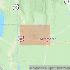
Mapped (geologic map, cross sections) as the lower member of the Eocene Green River Formation in central part of map area, Lincoln Co, WY, Greater Green River basin. Overlaps main body of Wasatch Formation. Overlain at most places by the Angelo Member of the Green River Formation or by mudstone tongue of Wasatch Formation. Consists mainly of tan and brown-weathering buff laminated limestone and marlstone, gray- to white-weathering brown to black oil shale, gray siltstone, mudstone, and claystone with some thin brown-weathering tuffaceous ash. These rocks grade laterally into algal, ostracodal, and gastropodal limestones that were deposited near the shore of ancient Fossil Lake. Fossils abundant--fish, leaves, insects, birds, reptiles, bats, etc.--especially in upper part. Ranges between 200 and 280 ft thick. Of late early to midddle Eocene age.
Source: GNU records (USGS DDS-6; Denver GNULEX).
For more information, please contact Nancy Stamm, Geologic Names Committee Secretary.
Asterisk (*) indicates published by U.S. Geological Survey authors.
"No current usage" (†) implies that a name has been abandoned or has fallen into disuse. Former usage and, if known, replacement name given in parentheses ( ).
Slash (/) indicates name conflicts with nomenclatural guidelines (CSN, 1933; ACSN, 1961, 1970; NACSN, 1983, 2005, 2021). May be explained within brackets ([ ]).