

- Usage in publication:
-
- Fortification basalt member*
- Modifications:
-
- Named
- Dominant lithology:
-
- Basalt
- AAPG geologic province:
-
- Plateau sedimentary province
- Great Basin province
Summary:
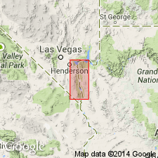
Named as a member of Muddy Creek formation for occurrence at Fortification Hill on southeast side of Lake Mead, Mohave Co, AZ in the Plateau sedimentary province. Mapped (geologic map) to east of Fortification Hill in AZ at Petroglyph Wash and south in small exposure in Black Mountains. Also mapped west of the Colorado River in Clark Co, NV in the Great Basin province at Malpais Flattop Mesa and at four small exposures west of the mesa. No type locality designated. Consists of basalt flows. No proof that all of the remnants represent same sequence of flows. All are black to dark-brown, vesicular or amygdaloidal, olivine basalt that are nearly horizontal. Where present, they form the top member of the Muddy Creek. They are conformable in older part of Muddy Creek. Some of the flows have numerous small vesicles, irregular in shape; others have rounded vesicles filled with white amygdules made of zeolite. Dark-brown tuff occurs between the flows at Fortification Hill. Local conglomerate lenses found near base at southeast corner of Fortification Hill. Assigned a Pliocene? age.
Source: GNU records (USGS DDS-6; Denver GNULEX).
- Usage in publication:
-
- Fortification Basalt Member*
- Modifications:
-
- Areal extent
- AAPG geologic province:
-
- Plateau sedimentary province
- Great Basin province
Summary:
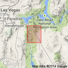
Mapped as a member in upper part of Muddy Creek Formation at scattered outcrops on both sides of the Colorado River in Mohave Co, AZ, Plateau sedimentary province and in Clark Co, NV, Great Basin province. Consists of lavas intercalated with and overlying sedimentary rocks of the Muddy Creek. Is mostly thin dark-gray to black olivine basalt with oxidized and brecciated contact zones. K-Ar ages of 4.9 m.y. obtained at BM 2257 and 5.8 m.y. at Malpais Flattop Mesa in an earlier study.
Source: GNU records (USGS DDS-6; Denver GNULEX).
- Usage in publication:
-
- Fortification Basalt Member*
- Modifications:
-
- Geochronologic dating
- AAPG geologic province:
-
- Great Basin province
- Plateau sedimentary province
Summary:
Is a member of the Muddy Creek Formation that was extruded into basin during late stages of Muddy Creek deposition. Samples for dating collected at Fortification Hill, Mohave Co, AZ, Plateau sedimentary province, at Black Mesa and Callville Wash, Clark Co, NV, Great Basin province, and southeast of Hoover Dam in AZ. Has isotopic ages (K-Ar) of 4.9 +/-0.4 to 11.3 +/-0.3 m.y., or Miocene and Pliocene age.
Source: GNU records (USGS DDS-6; Denver GNULEX).
For more information, please contact Nancy Stamm, Geologic Names Committee Secretary.
Asterisk (*) indicates published by U.S. Geological Survey authors.
"No current usage" (†) implies that a name has been abandoned or has fallen into disuse. Former usage and, if known, replacement name given in parentheses ( ).
Slash (/) indicates name conflicts with nomenclatural guidelines (CSN, 1933; ACSN, 1961, 1970; NACSN, 1983, 2005, 2021). May be explained within brackets ([ ]).