The National Geologic Map Database is migrating to a new infrastructure. We apologize for any service disruptions during this process.
|
|---|


- Usage in publication:
-
- Fort Shafter gravel
- Modifications:
-
- Original reference
- Dominant lithology:
-
- Alluvium
- AAPG geologic province:
-
- Oahu
Summary:
Pg. 62, 64, 65-71. Fort Shafter gravel. There are 5 principal formations in Salt Lake district. The oldest is Koolau basalt, which is followed by the older parts of the reef limestone. Next younger is Fort Shafter gravel, a coarse alluvial gravel, commonly made up of cobbles and boulders from 10 to 40 cm diameter embedded in matrix of poorly sorted finer alluvium. Thickness of beds 2 to 10 feet. At many places the gravel rests on basalt. It is deeply weathered; of Pleistocene age; and the combined work of several streams draining this part of Koolau Range probably when sea stood about 40 feet higher than now. Inner margin of Fort Shafter terrace in places stands 125 feet or more above sea level. Most striking remnant of the terrace is that on which Fort Shafter military post is located, and which is here called Fort Shafter terrace. The lowest (oldest) tuff of Salt Lake region is interbedded with Fort Shafter gravels at a number of places. Over Fort Shafter terrace the upper tuff is 1 to 5 feet thick and lies on the weathered and soil-covered surface of Fort Shafter gravel.
[GNC remark (ca. 1938, US geologic names lexicon, USGS Bull. 896, p. 765): Not differentiated by H.T Stearns 1935 report (Geol. and ground water res. Island of Oahu, Hawaii Div. Hydrog. Bull., no. 1).]
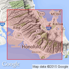
[Named from Fort Shafter military post in Honolulu (approx. Lat. 21 deg. 20 min. 26 sec. N., Long. 157 deg. 52 min. 51 sec. W., Honolulu 7.5-min quadrangle, Honolulu Co.), Island of Oahu, HI (additional locality information from USGS GNIS database and USGS historical topographic map collection TopoView, accessed on July 20, 2023).]
Source: US geologic names lexicon (USGS Bull. 896, p. 759-760).
- Usage in publication:
-
- Fort Schafter[sic] gravel
- Modifications:
-
- Principal reference
- Dominant lithology:
-
- Alluvium
- AAPG geologic province:
-
- Oahu
Summary:
Pg. 82-83. Fort Schafter[sic] gravel included by Stearns [IN Stearns and Vaksvik, 1935, Hawaii Div. Hydrog. Bull., no. 1] in older alluvium. Underlies lowest tuff of Honolulu volcanic series in area northeast of Pearl Harbor. Age is considered Pleistocene(?). Type locality.
[Principal reference locality]: bluff on edge of Fort Shafter Terrace overlooking Moanalau Gardens and lower gorge of Moanalau Stream, south side of Koolau Range about 17 mi west of Makapuu Head, Island of Oahu, HI.
Source: US geologic names lexicon (USGS Bull. 1200, p. 1402).
For more information, please contact Nancy Stamm, Geologic Names Committee Secretary.
Asterisk (*) indicates published by U.S. Geological Survey authors.
"No current usage" (†) implies that a name has been abandoned or has fallen into disuse. Former usage and, if known, replacement name given in parentheses ( ).
Slash (/) indicates name conflicts with nomenclatural guidelines (CSN, 1933; ACSN, 1961, 1970; NACSN, 1983, 2005, 2021). May be explained within brackets ([ ]).