

- Usage in publication:
-
- Fort Hancock Formation
- Modifications:
-
- Original reference
- Dominant lithology:
-
- Clay
- Silt
- Sand
- Gypsum
- AAPG geologic province:
-
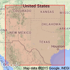
- Permian basin
Summary:
Fort Hancock Formation. Composed of clay, silt, fine sand, and gypsum. Unconformably underlies Camp Rice Formation (new). Fossils indicate Fort Hancock is probably Aftonian [Pleistocene].
Source: US geologic names lexicon (USGS Bull. 1350, p. 266-267).
- Usage in publication:
-
- Fort Hancock Formation
- Modifications:
-
- Original reference
- Dominant lithology:
-
- Claystone
- Siltstone
- Sandstone
- Gypsum
- AAPG geologic province:
-
- Permian basin
Summary:
Pg. 16-19, 51, 52, 53, 54. Fort Hancock Formation. Formal proposal of name. Consists of horizontal strata composed of bentonitic claystone, siltstone, and silt, ranging in color from grayish-red to shades of brown and occasionally to greenish-yellow, with yellowish-brown most common. Composite section reveals thickness of about 350 feet, but maximum thickness measurable at any single outcrop is about 80 feet. Lower boundary not exposed. Upper limit is unconformity which separates Fort Hancock from overlying Camp Rice. Exposures of formation form typical badlands-type topography unless they are protected by overlying Camp Rice where they form steep slopes. Blancan fauna establish age of upper part of formation as probably Aftonian [Pleistocene]. Type section and reference section designated.
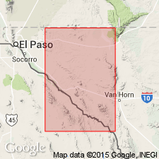
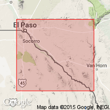
Type section: on east side of arroyo in NW/4 NW/4 sec. 19, T. 7, Blk. 73, Hudspeth Co., southwestern TX.
Type locality: 3.5 mi S. 84 deg. W. of Finlay, TX.
Reference section: on east side of Campo Grande Arroyo in SE/4 NE/4 sec. 9, T. 7, Blk. 74, Hudspeth Co., southwestern TX.
[Formation exposed in Rio Grande Valley in El Paso and Hudspeth Cos., TX, and adjacent to the Rio Grande in Chihuahua, Mexico.]
Source: US geologic names lexicon (USGS Bull. 1350, p. 266-267).
- Usage in publication:
-
- Fort Hancock Formation
- Modifications:
-
- Areal extent
- AAPG geologic province:
-
- Orogrande basin
Summary:
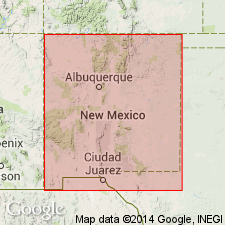
Mapped in Cerro de Cristo Rey, Dona Ana Co, NM, Orogrande basin and Chihuahua, MX. Consists of basal conglomerate and interbedded sand and clay beds; cobbles and boulders are mainly andesite on north and east sides of Cristo Rey and mainly felsite on south side. Basal conglomerate forms most of unit in map area. Thickness variable but generally in tens of ft in map area. Forms valley fill on east side of Franklin Mountains northeast of study area and where Fort Hancock may be as thick as 9000 ft. Deposits are lake and fluvial sediments that cover all pre-Cenozoic rocks of region except for those around local intrusions and in Franklin Mountains. Cross sections. Tertiary (Blancan) and Quaternary age based on fossils (Strain, 1973, pers. comm.) [fossils not discussed].
Source: GNU records (USGS DDS-6; Denver GNULEX).
- Usage in publication:
-
- Fort Hancock Formation
- Modifications:
-
- Biostratigraphic dating
- Paleomagnetics
- AAPG geologic province:
-
- Permian basin
Summary:
Pg. 241 (fig. 7.1), 248 (fig. 7.3), 263. Fort Hancock Formation. Blancan fauna identified from the Fort Hancock and overlying Camp Rice Formation in Hueco Bolson, southwest of Hueco Mountains, western Trans-Pecos Texas. Although the two formations are separated by an unconformity, the material from both were combined as the Hudspeth fauna. Small animals were recovered from the Fort Hancock and large animals from the Camp Rice. Paleomagnetic data for this sequence were obtained by Vanderhill (unpub. PhD dissert., Univ. Texas-Austin, 1986). Most of the Fort Hancock and lower part of Camp Rice fall in a normal interval that Vanderhill identified as the late Gauss chron (presumably chron C2An.1n). Age is constrained by presence of Huckleberry Ridge Ash (between 1.96 +/-0.2 Ma and 2.10 +/-0.02 Ma; p. 234, table 7.1) high in section.
Source: Publication.
For more information, please contact Nancy Stamm, Geologic Names Committee Secretary.
Asterisk (*) indicates published by U.S. Geological Survey authors.
"No current usage" (†) implies that a name has been abandoned or has fallen into disuse. Former usage and, if known, replacement name given in parentheses ( ).
Slash (/) indicates name conflicts with nomenclatural guidelines (CSN, 1933; ACSN, 1961, 1970; NACSN, 1983, 2005, 2021). May be explained within brackets ([ ]).