The National Geologic Map Database is migrating to a new infrastructure. We apologize for any service disruptions during this process.
|
|---|


- Usage in publication:
-
- Fort Collins Member
- Modifications:
-
- Named
- Dominant lithology:
-
- Sandstone
- AAPG geologic province:
-
- Denver basin
Summary:
Named Fort Collins Member, lower member of Muddy Sandstone of Lower Cretaceous Dakota Group. Is equivalent to lower part of first sandstone of South Platte Formation of earlier reports. South Platte Formation is restricted in this report to area south of Boulder, Colorado. Consists of white, very fine-grained clayey sandstone with abundant invertebrate tracks and trails on bedding planes, and burrows up to 1 cm in diameter. Is subangular to subround quartz with 5 to 20 percent chert. Feldspar rare to absent. Matrix is kaolin and sericite. Some subhorizontal to low-angle cross stratification. Is 12 to 50 feet thick. Upper contact with Horsetooth Member (new) of Muddy is sharp and flat. Lower contact with Skull Creek Shale (replaces use of middle part, South Platte in this area) is transitional, a change from white- to dark-gray shale. Lower contact is also intensely burrowed. Becomes darker colored to south of type and merges with Skull Creek. Traceable north to Boxelder Creek, sec. 9, T. 10 N., R. 69 W. Difficult to separate from overlying Horsetooth north of Owl Canyon. Extends east in subsurface at least as far as Weld County. Is a shallow-water marine unit deposited during a late shoaling stage. Correlates with lower part of "J" sandstone and Newcastle Sandstone. Report includes correlation chart.
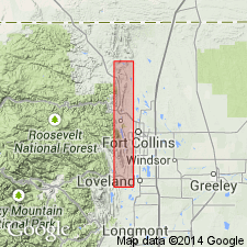
Named from town of Fort Collins, Larimer Co., CO, in Denver basin. Type section [also called type locality] is in a roadcut 0.15 mi east of south end of Spring Canyon Dam, N/2 SE/4 sec. 32, T. 7 N., R. 69 W.
Source: Modified from GNU records (USGS DDS-6; Denver GNULEX).
For more information, please contact Nancy Stamm, Geologic Names Committee Secretary.
Asterisk (*) indicates published by U.S. Geological Survey authors.
"No current usage" (†) implies that a name has been abandoned or has fallen into disuse. Former usage and, if known, replacement name given in parentheses ( ).
Slash (/) indicates name conflicts with nomenclatural guidelines (CSN, 1933; ACSN, 1961, 1970; NACSN, 1983, 2005, 2021). May be explained within brackets ([ ]).