The National Geologic Map Database is migrating to a new infrastructure. We apologize for any service disruptions during this process.
|
|---|


- Usage in publication:
-
- Forbes formation
- Modifications:
-
- [Principal reference]
- Dominant lithology:
-
- Shale
- Siltstone
- AAPG geologic province:
-
- Sacramento basin
Kirby, J.M., 1943, Rumsey Hills area [California]: California Division of Mines Bulletin, no. 118, pt. 3, p. 601-605., See also AAPG Bull., v. 25, no. 11, p. 2095, 1941 [abs.], Oil Weekly, v. 103, no. 7, p. 57-58, 1941, AAPG Bull., v. 26, no. 5, p. 899, 1942 [abs.], and AAPG Bull., v. 27, no. 3, p. 279-305, 1943 [Available online, with subscription, from AAPG archives: http://www.aapg.org/datasystems or http://search.datapages.com]
Summary:
Pg. 601-605; see also J.M. Kirby, Sites region [California], same vol., p. 606-608. Forbes formation of Chico group. Well-bedded to massive, light greenish gray to gray, carbonaceous siltstones and silty shales. Includes thin zones of fine- to coarse-grained sandstone. Basal 250 to 300 feet is gray or bluish-gray shale containing well-preserved foraminiferal fauna, notably MARGINULINA JONESI. Total thickness 1,300 feet in Salt Creek, 1,875 feet in Petroleum Creek, and 3,065 feet in Dunnigan Creek, Yola and Colusa Counties, northern California. Conformably overlies Upper Cretaceous Guinda formation of Chico group; disconformably underlies upper Pliocene Tehama formation. Age is Late Cretaceous [Chico].
Source: Publication.
- Usage in publication:
-
- Forbes formation
- Modifications:
-
- Principal reference
- Dominant lithology:
-
- Shale
- Siltstone
- AAPG geologic province:
-
- Sacramento basin
Summary:
Pg. 282-283, 291, 293. Forbes formation. Described as chiefly shale and siltstone with minor thin sandstones. Exposed thickness up to 3,000+/- feet. Underlies upper Pliocene Tehama gravels; conformably overlies Guinda formation. Type locality designated. Age is Late Cretaceous (Chico).
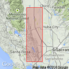
Type locality: on crest and east flank of Rumsey Hills [western foothill belt of Sacramento Valley, east and north of Rumsey], in T. 12 and 13 N., R. 3 W., Yolo [and Colusa Cos.], northern CA. [Origin of name not stated.]
Notable exposures in Salt, Petroleum, and Dunnigan Creeks, Yolo [and Colusa Cos.], northern CA.
Source: Publication; US geologic names lexicon (USGS Bull. 1200, p. 1384).
For more information, please contact Nancy Stamm, Geologic Names Committee Secretary.
Asterisk (*) indicates published by U.S. Geological Survey authors.
"No current usage" (†) implies that a name has been abandoned or has fallen into disuse. Former usage and, if known, replacement name given in parentheses ( ).
Slash (/) indicates name conflicts with nomenclatural guidelines (CSN, 1933; ACSN, 1961, 1970; NACSN, 1983, 2005, 2021). May be explained within brackets ([ ]).