

- Usage in publication:
-
- Fond du Lac sandstone
- Modifications:
-
- Original reference
- Dominant lithology:
-
- Sandstone
- Conglomerate
- Shale
- AAPG geologic province:
-
- Lake Superior region
- Sioux uplift
- Wisconsin arch
Summary:
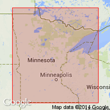
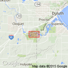
Pg. 567, pl. 88. Fond du lac sandstone. Exposed on both banks of St. Louis River from Fond du Lac [St. Louis County, northeastern Minnesota] westward to point at which it is replaced by the quartzose pebbly conglomerate that lies unconformably on Thomson slates. Is about contemporaneous with some of Manitou flows of Keweenawan. Upper strata are almost free from the shaly red sediment that characterizes lower portion. The rock thus gradually becomes a pinkish and finally a nearly white sandrock well known as building stone at Hinckley and on Kettle River. Lower part consists of fine red conglomerates, red shales, and sandstones. [Age is pre-Cambrian (Keweenawan?).]
Source: US geologic names lexicon (USGS Bull. 896, p. 747).
- Usage in publication:
-
- Fond du Lac sandstone
- Modifications:
-
- Revised
- AAPG geologic province:
-
- Lake Superior region
- Sioux uplift
Summary:
Pl. 37, map, and text describing pl. 56 [Carlton County, by N.H. Winchell]. Placed Fond du Lac sandstone, 157 feet thick, below Hinckley sandstone (381 feet thick) and above Potsdam red quartzite. "To these sandstones, therefore, the name Potsdam is also extended. They are of the date of the waning stages of the Keweenawan." [Age is pre-Cambrian (Keweenawan?).]
Source: US geologic names lexicon (USGS Bull. 896, p. 747).
- Usage in publication:
-
- Fond du Lac sandstone
- Modifications:
-
- Not used
- AAPG geologic province:
-
- Lake Superior region
- Sioux uplift
- Wisconsin arch
Summary:
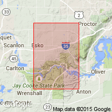
Pg. 469-475. The best Minnesota outcrop of Red Clastic series, free from glacial debris, is that along St. Louis River at Fond du Lac [in Esko 7.5-min quadrangle, St. Louis Co.], where measured thickness lies somewhere between 412 feet, as given by Winchell, and 730 feet as given by Thwaites.
Source: US geologic names lexicon (USGS Bull. 896, p. 747).
- Usage in publication:
-
- Fond du Lac beds
- Modifications:
-
- Revised
- AAPG geologic province:
-
- Lake Superior region
- Sioux uplift
Summary:
Pg. 10, 12-15. Fond du Lac beds are lower formation in Lake Superior series. Occur below Hinckley sandstone. Contact with Hinckley not exposed in east-central part of southeastern Minnesota. Thickness 235 feet at Fond du Lac [in Esko 7.5-min quadrangle, St. Louis Co.]. Base not exposed. [Age is Precambrian.]
Source: US geologic names lexicon (USGS Bull. 1200, p. 1382).
- Usage in publication:
-
- Fond du Lac beds
- Modifications:
-
- Revised
- AAPG geologic province:
-
- Lake Superior region
Summary:
Pg. 1058-1061. Fond du Lac beds included in upper part of Keweenawan group. Thickness several hundred to more than 2,000 feet. [Age is Precambrian.]
Source: US geologic names lexicon (USGS Bull. 1200, p. 1382).
- Usage in publication:
-
- Fond du Lac Formation
- Modifications:
-
- Principal reference
- Revised
- AAPG geologic province:
-
- Lake Superior region
- Sioux uplift
- Wisconsin arch
Summary:
Fond du Lac Formation. Predominantly lenticular beds of red sandstone and siltstone interbedded with shale. Lenses of conglomerate beds containing clasts of quartz, basalt, felsite, chert, and quartzite are common. Basal 60 feet includes quartz-pebble conglomerate previously assigned to the lower Keweenawan. Exposed thickness 300 feet; inferred to be 800+ feet. Subsurface correlative referred to as Red Clastic series. Underlies unconsolidated Pleistocene clay and fine sand. Overlies Middle Precambrian Thomson Formation of Animikie Group, which is intruded by middle Keweenawan age (1,100 Ma) dikes and sills of diabasic gabbro. Age is Late Precambrian (late Keweenawan), [based on stratigraphic relations].
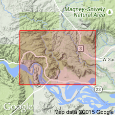
Type section (composite): [in Esko 7.5-min quadrangle], beginning in Fond du Lac area, along St. Louis River, in sec. 6, T. 48 N., R. 15 W., St. Louis Co., northeastern MN, and Douglas Co., northwestern WI, and continuing westward along Little River, in sec. 1, T. 48 N., R. 16 W., Carlton Co., northeastern MN.
[Misprint (GNC index card files, USGS-Reston): Fond du Lac Formation of North Shore Volcanic Group incorrect; the Fond du Lac lies above the North Shore (undivided in area of report; see Table 1 on p. 3).]
Source: Publication; GNC index card files (USGS-Reston)

- Usage in publication:
-
- Fond du Lac Formation*
- Modifications:
-
- Overview
- AAPG geologic province:
-
- Lake Superior region
- Sioux uplift
- Wisconsin arch
Summary:
Part of youngest Proterozoic sedimentary sequence in Lake Superior region, east-central and southeast MN. With overlying Hinckley Sandstone, is correlated with Bayfield Group in WI. Considered typical red bed sequence of fluvial and lacustrine origin. Is of normal magnetic polarity. Has paleomagnetic pole position similar to other Middle Proterozoic rocks in area. Unconformably overlies Solor Church Formation.
Source: GNU records (USGS DDS-6; Denver GNULEX).
For more information, please contact Nancy Stamm, Geologic Names Committee Secretary.
Asterisk (*) indicates published by U.S. Geological Survey authors.
"No current usage" (†) implies that a name has been abandoned or has fallen into disuse. Former usage and, if known, replacement name given in parentheses ( ).
Slash (/) indicates name conflicts with nomenclatural guidelines (CSN, 1933; ACSN, 1961, 1970; NACSN, 1983, 2005, 2021). May be explained within brackets ([ ]).