

- Usage in publication:
-
- Flint River formation*
- Modifications:
-
- Named
- Dominant lithology:
-
- Chert
- AAPG geologic province:
-
- South Georgia sedimentary province
- Atlantic Coast basin
- Florida platform
Summary:
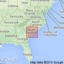
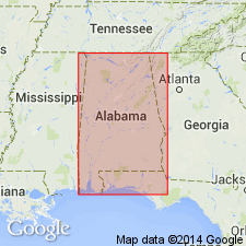
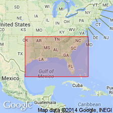
According to author, his 1923 tentative correlation of the chert beds of GA and southeastern AL with Glendon limestone now appears doubtful, and these beds, which are present in northern FL, southeastern AL, GA, and southwestern SC, are here given the tentative name Flint River formation, from exposures on Flint River and assigned to the Vicksburg group. Their fauna appears to be more closely related to Chickasawhay marl member of Byram marl of southeastern MS than to Glendon limestone. In SC, the formation is present in Allendale Co., only.
Source: GNU records (USGS DDS-6; Reston GNULEX).
- Usage in publication:
-
- Flint River formation*
- Modifications:
-
- Areal extent
- Overview
- AAPG geologic province:
-
- Atlantic Coast basin
Summary:
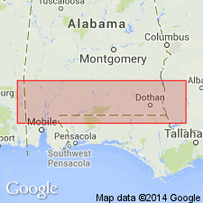
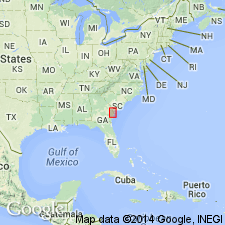
In SC, Flint River formation occurs only in narrow strip bordering Savannah River in Allendale Co. from vicinity of Johnsons Landing to Cohens Bluff. The beds consists chiefly of broken lumps of yellow vitreous chert in reddish yellow sand. Few Fossils. These beds are tentatively correlated with the upper or Chickasawhay member of Byram marl of MS and southwestern AL, and so far as now known, they are the sole representative of the Vicksburg group in southeastern AL, GA, and SC.
Source: GNU records (USGS DDS-6; Reston GNULEX).
- Usage in publication:
-
- Flint River formation*
- Modifications:
-
- Age modified
- AAPG geologic province:
-
- South Georgia sedimentary province
Summary:
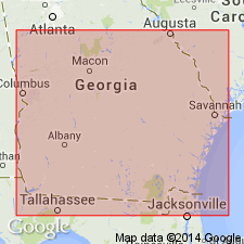
Flint River formation, formerly supposed to be facies of Glendon limestone, has proved to be somewhat younger. Tentatively correlated with Chickasawhay member of Byram of MS. Formation overlaps Eocene formations as far as the Clayton. East of Oconee River, it is overlapped by Hawthorn formation, but reappears in Savannah drainage basin. Report is about the coastal plain of GA.
Source: GNU records (USGS DDS-6; Reston GNULEX).
- Usage in publication:
-
- Flint River formation*
- Modifications:
-
- Age modified
- AAPG geologic province:
-
- South Georgia sedimentary province
Summary:
Recent mapping in southwestern AL has shown that Flint River is not a single unit of deposition, but a mixture of argillaceous and siliceous residuum of Oligocene limestones and disarranged beds of Miocene formations. It appears, therefore, that except at its northward extremity, where Tampa and Hawthorn beds have been eroded away or were never deposited, the Flint River contains material of Oligocene, if the residuum of the Ocala is excluded from it, Miocene, and possibly of more recent age. If the formation is to be dated from time that it assumed its present form, it is probably largely Pleistocene or Holocene.
Source: GNU records (USGS DDS-6; Reston GNULEX).
- Usage in publication:
-
- Flint River†
- Modifications:
-
- Abandoned
- AAPG geologic province:
-
- South Georgia sedimentary province
Summary:
Author suggests that name Flint River be abandoned and that the heterogeneous beds to which name was applied be designated as residuum of Jackson, Oligocene, and Miocene, undifferentiated. [Formation was not officially abandoned at the time this manuscript was reviewed by the GNU, if in fact the manuscript was reviewed sometime prior to 1946. Since C.W. Cooke did not want the name abandoned as of October 28, 1958, as he planned to use it in a Professional Paper, the name is retained.]
Source: GNU records (USGS DDS-6; Reston GNULEX).
- Usage in publication:
-
- Flint River formation*
- Modifications:
-
- Reinstated
- AAPG geologic province:
-
- South Georgia sedimentary province
- Atlantic Coast basin
Summary:
In discussion of Cenozoic echinoids, age of Flint River formation in GA is given as late Oligocene.
Source: GNU records (USGS DDS-6; Reston GNULEX).
- Usage in publication:
-
- Flint River
- Modifications:
-
- Not used
- AAPG geologic province:
-
- South Georgia sedimentary province
Summary:
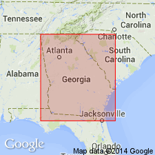
Author agrees with MacNeil (1944, 1946, 1947) that the Flint River is an invalid lithostratigraphic unit and should not be used. However, the cherty, clayey residuum originally included in the Flint River covers large areas of the GA Coastal Plain and cannot be ignored. Although it consists of weathered deposits of middle Eocene to Miocene age, the majority has been derived from Oligocene marine deposits. It is possible that much of it came from the weathering and leaching of the Bucatunna Clay. The residuum is known to occur in GA from the Chattahoochee River in the west to the Oconee River in the east. North of the Dougherty Plain, it overlies the Lisbon Formation and Factory Creek Formation of Huddlestun and others (in review). Elsewhere overlies the Ocmulgee Formation and locally may overlie the Tobacco Road Sand. Underlies either the Hawthorne Group or Altamaha Formations.
Source: GNU records (USGS DDS-6; Reston GNULEX).
For more information, please contact Nancy Stamm, Geologic Names Committee Secretary.
Asterisk (*) indicates published by U.S. Geological Survey authors.
"No current usage" (†) implies that a name has been abandoned or has fallen into disuse. Former usage and, if known, replacement name given in parentheses ( ).
Slash (/) indicates name conflicts with nomenclatural guidelines (CSN, 1933; ACSN, 1961, 1970; NACSN, 1983, 2005, 2021). May be explained within brackets ([ ]).