

- Usage in publication:
-
- Fivemile Brook Formation
- Modifications:
-
- Named
- Biostratigraphic dating
- Dominant lithology:
-
- Slate
- Limestone
- Greenstone
- AAPG geologic province:
-
- New England province
Summary:
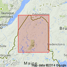
A sequence of sedimentary and volcanic rocks in northern ME, partly equivalent to the "Fivemile Brook sequence" of Boudette and others (1976), is here named the Fivemile Brook Formation. Sedimentary rocks consist of medium-gray, orange-buff weathering, calcareous slate and lenses of gray biomicritic limestone containing crinoidal debris. The informal greenstone member, mostly in the lower part of the formation, consists of a 0 to 1,000 m interval of andesitic igneous rocks which form sills, flows, and pyroclastic layers. An upper lentil of andesitic(?) volcanics is suggested by magnetic anomalies, although no outcrops have been seen. Conformably or disconformably overlies the Depot Mountain Formation; underlies the Seboomook Formation along a 40 km (25 mi) long straight contact that may be stratigraphic or a fault. Thickness varies from 300 to 1,800 m. Age is Late Silurian based on fossils (Boudette and others, 1976).
Source: GNU records (USGS DDS-6; Reston GNULEX).
- Usage in publication:
-
- Fivemile Brook Formation
- Modifications:
-
- Redescribed
- Dominant lithology:
-
- Phyllite
- Limestone
- Lava
- AAPG geologic province:
-
- New England province
Summary:
The preliminary discussion in Roy (1980) is here revised. The Fivemile Brook Formation consists of light-greenish-gray calcareous phyllite with thin beds and lenses of argillaceous biomicritic limestone and four mappable sequences of basaltic lava. Age is Late Silurian (Ludlovian) based on corals (Boudette and others, 1976).
Source: GNU records (USGS DDS-6; Reston GNULEX).
For more information, please contact Nancy Stamm, Geologic Names Committee Secretary.
Asterisk (*) indicates published by U.S. Geological Survey authors.
"No current usage" (†) implies that a name has been abandoned or has fallen into disuse. Former usage and, if known, replacement name given in parentheses ( ).
Slash (/) indicates name conflicts with nomenclatural guidelines (CSN, 1933; ACSN, 1961, 1970; NACSN, 1983, 2005, 2021). May be explained within brackets ([ ]).