

- Usage in publication:
-
- Finnie sandstone
- Modifications:
-
- Original reference
- Dominant lithology:
-
- Sandstone
- AAPG geologic province:
-
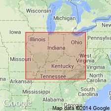
- Illinois basin
Summary:
Pg. 13, 14, 23, 24. Finnie sandstone in Tradewater formation. Sandstone, 0 to 50 feet thick, in Tradewater formation, in interval between coals Nos. 2 and 3. Owen's coal No. 2 lies about 16 feet below it. Lower part contains irregular shaly lenses, coal steaks, and shale breccia or conglomerate; upper part, gently cross-bedded, of alternating white and purplish laminae, medium-grained. Age is Pennsylvanian. Recognized in western Kentucky and southeastern Illinois(?).
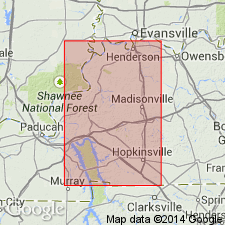
Named from Finnie Bluff, on road north of Milfordtown, Union Co., KY.
[GNC remark (ca. 1936, US geologic names lexicon, USGS Bull. 896, p. 732): Finnie Bluff sandstone is a name applied by some Kentucky geologists to Finnie sandstone of other geologists.]
Source: US geologic names lexicon (USGS Bull. 1200, p. 732).
- Usage in publication:
-
- Finnie sandstone
- Modifications:
-
- Areal extent
- AAPG geologic province:
-
- Illinois basin
Summary:
Pg. 34, 83. Finnie sandstone in Tradewater formation. Massive sandstone in lower part of Tradewater formation between Ice House above and Bell coals; locally attains maximum thickness of 60 to 80 feet. Recognized in Indiana.
Source: US geologic names lexicon (USGS Bull. 1200, p. 1350-1351).

- Usage in publication:
-
- Finnie sandstone member
- Modifications:
-
- Revised
- AAPG geologic province:
-
- Illinois basin
Summary:
Pg. 31, 44 (table 1), 62. Finnie sandstone member of Abbott formation (new) of McCormick group (new). Reallocated to member status in Abbott formation. Replaces name Delwood sandstone so that term Delwood may be retained for the coal. Overlies Willis coal member (new); underlies Delwood coal member (new). Thickness about 60 feet at type section of Abbott. Age is Pennsylvanian. Type locality stated. Presentation of new rock-stratigraphic classification of Pennsylvanian strata in Illinois; cyclical classification is independent of rock-stratigraphic classification.
Type locality: along road for less than 2 mi north of Mulfordtown [Milfordtown] near Caseyville, Union Co., KY.
Source: US geologic names lexicon (USGS Bull. 1200, p. 1350-1351).

- Usage in publication:
-
- Finnie
- Modifications:
-
- Not used
- Areal extent
- AAPG geologic province:
-
- Illinois basin
Summary:
Finnie Sandstone Member of Abbott Formation not used. Correlation of the Finnie into southern Illinois (Kosanke and others, 1960) is questionable, according to the authors. Middle Abbott sandstones in the report area are too lenticular to warrant formal names.
Source: Modified from GNU records (USGS DDS-6; Reston GNULEX).
For more information, please contact Nancy Stamm, Geologic Names Committee Secretary.
Asterisk (*) indicates published by U.S. Geological Survey authors.
"No current usage" (†) implies that a name has been abandoned or has fallen into disuse. Former usage and, if known, replacement name given in parentheses ( ).
Slash (/) indicates name conflicts with nomenclatural guidelines (CSN, 1933; ACSN, 1961, 1970; NACSN, 1983, 2005, 2021). May be explained within brackets ([ ]).