The National Geologic Map Database is migrating to a new infrastructure. We apologize for any service disruptions during this process.
|
|---|


- Usage in publication:
-
- Fiftymile Member*
- Modifications:
-
- Named
- Dominant lithology:
-
- Sandstone
- Mudstone
- Conglomerate
- AAPG geologic province:
-
- Plateau sedimentary province
Summary:
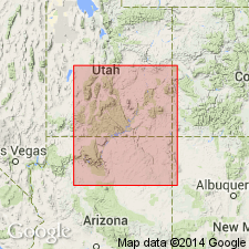
Named as member of Upper Jurassic Morrison Formation for type section 2 km northwest of Fiftymile point. Type section measured and described on northeast-trending ridge in SW1/4 SE1/4 sec 11, NW1/4 NE1/4 sec 14, T41S, R8E, Kane Co, UT, Plateau sedimentary province. Is 107.1 m thick at type where it overlies Salt Wash Member of Morrison and unconformably (K-1) underlies Dakota Formation. Lower contact placed at base of lowest thick mudstone above thick sandstone of Salt Wash. Overlying Dakota recognized by plant fragments. Present in southeast part of Kaiparowits basin, Kane Co. Same beds formerly included in Salt Wash because they contained significant amounts of sandstone. However, regional relationships indicate beds are facies of younger Brushy Basin Member of Morrison. Composed of light-brown to light-gray, fine-grained sandstone. Beds may contain pebbles, be cross-bedded, flat laminated, or massive. Those in lower part are laminated to thin-bedded. Conglomerate is (pebbles of red, orange, tan, green, black, gray, white, brown, and banded chert) scarce--known as "Christmas tree conglomerate"--type common also in Brushy Basin. Includes green, laminated to very thin-bedded mudstone. Uppermost beds bleached beneath K-1 unconformity. Forms ledges and slopes above Salt Wash. Is proximal facies of lower part of Brushy Basin, deposited in mudflat, nearshore lacustrine and fluvial environment. Of Late Jurassic age. Cross sections.
Source: GNU records (USGS DDS-6; Denver GNULEX).
For more information, please contact Nancy Stamm, Geologic Names Committee Secretary.
Asterisk (*) indicates published by U.S. Geological Survey authors.
"No current usage" (†) implies that a name has been abandoned or has fallen into disuse. Former usage and, if known, replacement name given in parentheses ( ).
Slash (/) indicates name conflicts with nomenclatural guidelines (CSN, 1933; ACSN, 1961, 1970; NACSN, 1983, 2005, 2021). May be explained within brackets ([ ]).