The National Geologic Map Database is migrating to a new infrastructure. We apologize for any service disruptions during this process.
|
|---|


- Usage in publication:
-
- Fierro limestone*
- Modifications:
-
- Named
- Dominant lithology:
-
- Limestone
- Chert
- Shale
- AAPG geologic province:
-
- Basin-and-Range province
Summary:
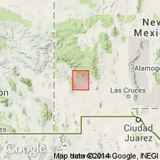
Named from town of Fierro, northeast part of Silver City quad, Grant Co, NM, Basin-and-Range province. No type locality designated; section 751 ft thick measured in gulch west of Silver City. Consists of fossiliferous limestone and includes beds of both Mississippian and Pennsylvanian age (based on fossils). Presence of the two faunas suggests an unconformity between upper and lower parts of formation, but no separation can be made by lithologic differences. Overlies Percha shale conformably; underlies Beartooth quartzite (new) unconformably. Ranges in color from light gray to dark blue or purplish. West of Silver City upper half of section is light gray or light blue and lower half, except where whitened (probably by intrusions), is darker blue. Except in lower 100 ft, beds are characteristically cherty, containing either white or black chert; red chert near base. Massive for most part, though it contains thin, more or less shaly beds. Crinoidal limestone is abundant in upper half of formation. Thickness varies, because of known unconformity at top and probable unrecognized one between Mississippian and Pennsylvanian beds. Lower part correlated with Lake Valley limestone. Exposed at Lone Mountain, and throughout the range northwest of Silver City, in areas east of Fort Bayard, and north of Santa Rita, in a small area west of Gomez Peak, and on west flank of Pinos Altos Mountain. Abundant fossils; fossil list. Geologic map.
Source: GNU records (USGS DDS-6; Denver GNULEX).
For more information, please contact Nancy Stamm, Geologic Names Committee Secretary.
Asterisk (*) indicates published by U.S. Geological Survey authors.
"No current usage" (†) implies that a name has been abandoned or has fallen into disuse. Former usage and, if known, replacement name given in parentheses ( ).
Slash (/) indicates name conflicts with nomenclatural guidelines (CSN, 1933; ACSN, 1961, 1970; NACSN, 1983, 2005, 2021). May be explained within brackets ([ ]).