

- Usage in publication:
-
- Ferguson Springs formation
- Modifications:
-
- Named
- Dominant lithology:
-
- Limestone
- AAPG geologic province:
-
- Great Basin province
Summary:
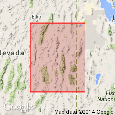
Pg. 93 (chart 1), 101, 104, (pl. 5, fig. 3). (Road logs dated Sept. 8-10.) Name applied to those limestones occurring above the middle Pennsylvanian regional unconformity and stratigraphically below Pequop formation (new) of Leonardian age. Outcrops distributed over an area of about 5,000 sq. mi.; extends into White Pine County, Nevada, and eastward into southwesternmost parts of Tooele and Box Elder Counties, Utah (see areal extent map). Is a light- to medium-gray, crypto- to fine-crystalline, bioclastic, silty, limestone sequence with thin interbeds of bituminous shale. White, gray, and black chert nodules and beds present locally. Fusulinid coquinas and massive coralline limestone present in the Virgilian and Wolfcampian beds. Thickness 3,185 feet at type section. Lower 1,101 feet dated late Pennsylvanian, with lower 592 feet assigned to Missourian, and remaining 519 feet to Virgilian. Upper 1,984 feet dated Wolfcampian. At nearly all known localities, including type area, formation rests disconformably on Ely limestone (restricted); unconformity is middle Pennsylvanian regional unconformity. In Cherry Creek Mountains (T. 28 N., R. 62 E., Elko Co., NV), underlies Riepetown sandstone (new); In Pequop Mountains (T. 33 N., R. 65 E., Elko Co., NV) and at Ferguson Springs (Elko Co., NV), underlies Pequop formation (new).
Type section: in sec. 16, T. 30 N., R. 69 E., Elko Co., NV (Great Basin province). Named from Ferguson Springs, 1.5 mi south of measured section [not published with this report].
Source: US geologic names lexicon (USGS Bull. 1200, p. 1338); supplemental information from GNU records (USGS DDS-6; Denver GNULEX).
For more information, please contact Nancy Stamm, Geologic Names Committee Secretary.
Asterisk (*) indicates published by U.S. Geological Survey authors.
"No current usage" (†) implies that a name has been abandoned or has fallen into disuse. Former usage and, if known, replacement name given in parentheses ( ).
Slash (/) indicates name conflicts with nomenclatural guidelines (CSN, 1933; ACSN, 1961, 1970; NACSN, 1983, 2005, 2021). May be explained within brackets ([ ]).