The National Geologic Map Database is migrating to a new infrastructure. We apologize for any service disruptions during this process.
|
|---|


- Usage in publication:
-
- Falor formation
- Modifications:
-
- Original reference
- Dominant lithology:
-
- Sandstone
- Clay
- Silt
- Conglomerate
- AAPG geologic province:
-
- Eel River basin
Summary:
Pg. 7, 14 (fig. 2), 22-25, pls. 1, 2. Falor formation. Poorly consolidated marine sandstones, clays, silts, and conglomerates. Thickness 750 to 2,000 feet; upper 200 feet are red beds. In fault contact with Franciscan. Beds strike approximately N. 40 deg. W., and dip homoclinally about 20 deg. NE. Name replaces term Boulder formation as used by authors in unpublished theses.
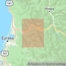
Type locality: along Maple Creek near Falor Ranch, Blue Lake quadrangle, Humboldt Co., northwestern CA.
Source: US geologic names lexicon (USGS Bull. 1200, p. 1319).
For more information, please contact Nancy Stamm, Geologic Names Committee Secretary.
Asterisk (*) indicates published by U.S. Geological Survey authors.
"No current usage" (†) implies that a name has been abandoned or has fallen into disuse. Former usage and, if known, replacement name given in parentheses ( ).
Slash (/) indicates name conflicts with nomenclatural guidelines (CSN, 1933; ACSN, 1961, 1970; NACSN, 1983, 2005, 2021). May be explained within brackets ([ ]).