

- Usage in publication:
-
- Fall River Granite
- Modifications:
-
- Named
- Dominant lithology:
-
- Granite
- Gneiss
- AAPG geologic province:
-
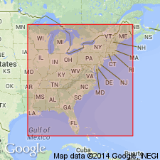
- New England province
Summary:
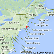
Fall River pluton of the MA State map (Zen and others, 1983) is here referred to as the Fall River Granite. According to the authors, the change in name is meant to indicate the heterogeneous nature of the granite and the fact that it may consist of more than a single pluton. Included in this unit is the Bulgarmarsh Granite of Fall River and a mass of alaskitic gneiss shown on the State map south of Fall River. No type section is designated. Geologic map shows the Fall River present in the New Bedford area of MA and RI and bounded on the west by the Narragansett Bay Group. The Fall River was dated by Zartman and Naylor (1984) at about 600 Ma (U-Th-Pb zircon).
Source: GNU records (USGS DDS-6; Reston GNULEX).
- Usage in publication:
-
- Fall River Granite*
- Modifications:
-
- Overview
- AAPG geologic province:
-
- New England province
Summary:
Fall River Granite used in table 11 of report.
Source: GNU records (USGS DDS-6; Reston GNULEX).
For more information, please contact Nancy Stamm, Geologic Names Committee Secretary.
Asterisk (*) indicates published by U.S. Geological Survey authors.
"No current usage" (†) implies that a name has been abandoned or has fallen into disuse. Former usage and, if known, replacement name given in parentheses ( ).
Slash (/) indicates name conflicts with nomenclatural guidelines (CSN, 1933; ACSN, 1961, 1970; NACSN, 1983, 2005, 2021). May be explained within brackets ([ ]).