The National Geologic Map Database is migrating to a new infrastructure. We apologize for any service disruptions during this process.
|
|---|


- Usage in publication:
-
- Evans Gulch porphyry*
- Modifications:
-
- Named
- Dominant lithology:
-
- Porphyry
- AAPG geologic province:
-
- Eagle basin
Summary:
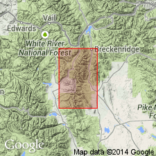
Named for exposures on north slope of Evans Gulch, Leadville district, Lake Co, CO in the Eagle basin. No type locality designated. Included as one of four named porphyries in the Gray porphyry group. Is fine and even grained. Porphyry has rectangular crystals of plagioclase up to 3 mm long embedded in a fine-grained groundmass. Plagioclase makes up 25 to 30 percent of the rock. Black to dark-green flakes of biotite altered to chlorite, colorless quartz grains, orthoclase associated with the quartz, calcite, epidote, sericite, albite, magnetite, apatite, and zircon are minor constituents. Resembles a granite at first glance. Chemical analyses. Geologic map. Occurs as one body in north-central part of map surrounded by Weber? formation. Assigned a Late Cretaceous or early Tertiary age.
Source: GNU records (USGS DDS-6; Denver GNULEX).
- Usage in publication:
-
- Evans Gulch Porphyry*
- Modifications:
-
- Overview
- AAPG geologic province:
-
- Eagle basin
Summary:
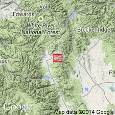
Occurs as a small stock, and as dikes and sills in the Leadville district, Lake Co, CO in the Eagle basin. Has not been dated; shown as equivalent to the Sacramento Porphyry (Tertiary), as younger than Lincoln Porphyry (Paleocene), and as older than the Johnson Gulch Porphyry (Tertiary). Is cut by the Johnson Gulch Porphyry in the Breece Hill area. Geologic map. Of Tertiary age.
Source: GNU records (USGS DDS-6; Denver GNULEX).
For more information, please contact Nancy Stamm, Geologic Names Committee Secretary.
Asterisk (*) indicates published by U.S. Geological Survey authors.
"No current usage" (†) implies that a name has been abandoned or has fallen into disuse. Former usage and, if known, replacement name given in parentheses ( ).
Slash (/) indicates name conflicts with nomenclatural guidelines (CSN, 1933; ACSN, 1961, 1970; NACSN, 1983, 2005, 2021). May be explained within brackets ([ ]).