The National Geologic Map Database is migrating to a new infrastructure. We apologize for any service disruptions during this process.
|
|---|


- Usage in publication:
-
- Eshamy granite*
- Modifications:
-
- Named
- Dominant lithology:
-
- Granite
- AAPG geologic province:
-
- Alaska Southern region
Summary:
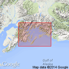
Practically surrounds Granite Bay and occupies nearly all of neck of land between Granite and Eshamy Bays, western part of Prince William Sound, southern AK. Consists of pinkish-gray granite of medium-grained granitoid texture, with outermost 2 or 3 inches stained brown by limonite. Intrudes graywacke of Valdez group; contact is very sharp. Cuts greenstone which is a diorite probably derived from a diabase. [Age is Mesozoic(?)].
Source: GNU records (USGS DDS-6; Menlo GNULEX).
- Usage in publication:
-
- Eshamy Granite*
- Modifications:
-
- Age modified
- Geochronologic dating
- AAPG geologic province:
-
- Alaska Southern region
Summary:
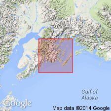
K-Ar age on biotite yielded 36.2 +/-1.0 Ma and on hornblende, 34.4 +/-1.2 Ma (Lanphere, 1966). Samples collected on east shore of Eshamy Lake, 60 deg 27'N, 148 deg 06'30"W. Along its east side, Eshamy Granite intruded pillow basalt and diabase of Orca Group. Contact metamorphism has affected sedimentary rocks between Nellie Juan Granite, Eshamy Granite and granite of Culross Island, suggesting that all these intrusive bodies may be connected at depth. Unit included in plutons of central Seward quad; map legend shows age as Oligocene.
Source: GNU records (USGS DDS-6; Menlo GNULEX).
For more information, please contact Nancy Stamm, Geologic Names Committee Secretary.
Asterisk (*) indicates published by U.S. Geological Survey authors.
"No current usage" (†) implies that a name has been abandoned or has fallen into disuse. Former usage and, if known, replacement name given in parentheses ( ).
Slash (/) indicates name conflicts with nomenclatural guidelines (CSN, 1933; ACSN, 1961, 1970; NACSN, 1983, 2005, 2021). May be explained within brackets ([ ]).