- Usage in publication:
-
- Enterprise shales
- Modifications:
-
- Original reference
- Dominant lithology:
-
- Shale
- AAPG geologic province:
-
- Salina basin
Summary:
Pg. 253. Enterprise shales. Shales, with some thin limestones near top; 44 feet thick; overlying Luta limestone and underlying Herington limestone. All included in Marion stage.
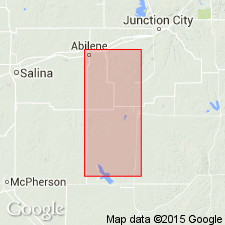
Named from Enterprise, Dickinson Co., central KS.
[Misprint (USGS Bull. 896, p. 691): cited Kansas Acad. Sci. Trans., v. 21; should be v. 22.]
Source: US geologic names lexicon (USGS Bull. 896, p. 691); GNC KS-NE Permian Corr. Chart, Oct. 1936.

- Usage in publication:
-
- Enterprise shale*
- Modifications:
-
- Overview
Summary:
In 1927 †Marion formation was abandoned by both Kansas Geol. Survey and the USGS, and Enterprise shale was elevated to rank of a formation within Sumner group.
Source: US geologic names lexicon (USGS Bull. 896, p. 691)

- Usage in publication:
-
- Enterprise shale member
- Modifications:
-
- Revised
- AAPG geologic province:
-
- Nemaha anticline
Summary:
Pg. 13. Enterprise shale of Sumner group. Divided into 3 members (descending): Paddock shale, Krider limestone, and Odell shale. Occurs below Herington limestone of Sumner group and above Winfield formation of Chase group. Age is Permian (Big Blue).
Source: US geologic names lexicon (USGS Bull. 896, p. 691); GNC KS-NE Permian Corr. Chart, Oct. 1936.

- Usage in publication:
-
- Enterprise shale†
- Modifications:
-
- Abandoned
Summary:
Pg. 12. †Enterprise shale. Discarded Enterprise, raised Odell shale to rank of a formation, and combined Condra's Krider limestone and Paddock shale with overlying Herington limestone into a newly named formation (Nolans limestone). These changes have not yet been considered by the USGS for its publications.
Source: US geologic names lexicon (USGS Bull. 896, p. 1586); GNC KS-NE Permian Corr. Chart, Oct. 1936.

- Usage in publication:
-
- Enterprise Shale†
- Modifications:
-
- Abandoned
Summary:
†Enterprise Shale of Sumner Group. Name not used on Geologic map of Oklahoma (1954). The Enterprise or its equivalents transferred to Chase Group.
Source: US geologic names lexicon (USGS Bull. 1200, p. 1268).
For more information, please contact Nancy Stamm, Geologic Names Committee Secretary.
Asterisk (*) indicates published by U.S. Geological Survey authors.
"No current usage" (†) implies that a name has been abandoned or has fallen into disuse. Former usage and, if known, replacement name given in parentheses ( ).
Slash (/) indicates name conflicts with nomenclatural guidelines (CSN, 1933; ACSN, 1961, 1970; NACSN, 1983, 2005, 2021). May be explained within brackets ([ ]).

