The National Geologic Map Database is migrating to a new infrastructure. We apologize for any service disruptions during this process.
|
|---|


- Usage in publication:
-
- Embudo granite
- Modifications:
-
- Named
- Dominant lithology:
-
- Granite
- AAPG geologic province:
-
- Southern Rocky Mountain region
Summary:
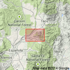
Named for Embudo, Rio Arriba Co, NM. No type locality designated. Replaces name Dixon granite of Just (1937), which is preempted. 4 mi east of Embudo are extensive outcrops. Borders Picuris Range on east and south, Rio Arriba and Taos Cos, NM, Southern Rocky Mountain region; occurs as several distinctive rock types--however, all from a single magma source. Rock type variability a function of: 1) degree of assimilation of foreign material by the granite, and type of rock assimilated; and 2) degree of shearing and metamorphism. Embudo hidden as an underlying batholith in northern part Picuris Range; partly exposed in southern and far-eastern parts. All occurrences show a microcline-rich granite relatively rich in potash and soda. 3 main granite types: 1) coarse-grained, partly porphyritic biotite granite; 2) light-colored, partly porphyritic gneissic granite; and 3) flesh-colored, coarse-grained to pegmatitic leucogranite. First is exposed over limited area near Canoncito; also forms entire granitic mass wherever exposed along front of range from 1 1/2 mi east of Harding mine, to 6 mi east and northeast. Second includes all granitic rock south, west, and northwest of Harding mine, excepting biotite granite just east of Canoncito. Third underlies both ridges bordering Arroyo Miranda, eastern end of range; forms much of interior highland east of Picuris Canyon. Contacts not discussed. Pre-Cambrian age. Geologic map, cross sections.
Source: GNU records (USGS DDS-6; Denver GNULEX).
- Usage in publication:
-
- Embudo Granite
- Modifications:
-
- Areal extent
- Overview
- AAPG geologic province:
-
- Southern Rocky Mountain region
Summary:
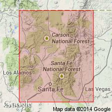
Embudo Granite extended into the report area. Borders the Picuris Range (Taos Co, NM, Southern Rocky Mountain region) on the east and south; southward from Picuris Range and west of the Picuris-Pecos fault, exposures become increasingly widespread. Here Embudo makes up the main mass of the Santa Fe Range, extending southward from Cordova for 30 mi in a continuous 8-mi-wide belt as far as Glorieta Baldy and the south end of the Sangre de Cristo Mountains (all in Santa Fe Co, NM, Southern Rocky Mountain region). East of Picuris-Pecos fault and southward from Picuris Range, Embudo does not appear for 15 mi. Its northernmost outcrops here are about 6 mi southeast of Truchas Peaks, along the upper Pecos River and along both the Valdez and Mora rivers (Rio Arriba Co, NM, Southern Rocky Mountain region). Southward from these latter two locations there stretches a 4-mi-wide zone of Embudo. Extensive outcrops exposed in the deep middle canyons of Rio Mora and Bear Creek suggest that this granite zone may extend 9 mi to south beneath Paleozoic sediments. Embudo is intrusive into and younger than Ortega and Vadito Formations. The pegmatite of the Harding mine in Picuris Range, genetically related to Embudo through mineralogy and field relationships (Montgomery, 1953), was recently dated by Aldrich, Weatherill, and Davis (1957) as 1,300 m.y [Middle Proterozoic age]; these determinations were based on Sr-Rb and K-Ar methods. Geologic map.
Source: GNU records (USGS DDS-6; Denver GNULEX).
- Usage in publication:
-
- Embudo granite complex
- Modifications:
-
- Areal extent
- AAPG geologic province:
-
- Southern Rocky Mountain region
Summary:
Name "Embudo granite complex" [as an informal term?] is retained in the Santa Fe Range, Santa Fe Co, NM in the Southern Rocky Mountain region, to a complex granitic terrain. The range may contain several granite bodies. However, the name "Embudo Granite" will not be used for any plutonic rocks in the Picuris Mountains. The original Embudo now known to include several distinct plutons [all informal units?] that vary in chemistry, mineralogy, and isotopic age--the "Puntiagudo granite porphyry" 1,684 +/-1 Ma, "Rana quartz monzonite" 1,674 +/-5 Ma, "Cerro Alto metadacite" and "Penasco quartz monzonite", about 1,450 Ma. Geologic map. Assigned a Proterozoic age.
Source: GNU records (USGS DDS-6; Denver GNULEX).
For more information, please contact Nancy Stamm, Geologic Names Committee Secretary.
Asterisk (*) indicates published by U.S. Geological Survey authors.
"No current usage" (†) implies that a name has been abandoned or has fallen into disuse. Former usage and, if known, replacement name given in parentheses ( ).
Slash (/) indicates name conflicts with nomenclatural guidelines (CSN, 1933; ACSN, 1961, 1970; NACSN, 1983, 2005, 2021). May be explained within brackets ([ ]).