The National Geologic Map Database is migrating to a new infrastructure. We apologize for any service disruptions during this process.
|
|---|


- Usage in publication:
-
- Elwell Formation
- Modifications:
-
- Named
- Dominant lithology:
-
- Chert
- Tuff
- AAPG geologic province:
-
- Sierra Nevada province
Summary:
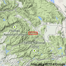
Unit is named the Elwell Formation. Type area is located along the ridge overlooking the valley west of Long Lake, SE 1/4 sec. 12, T21N R11E [Gold Lake 7.5' quad], Plumas Co., CA. Probably named for Mount Elwell 0.5 km northwest of Long Lake. Consists of black and gray radiolarian chert interbedded with andesitic tuff. Thickness ranges from 90 to 300 m. Overlies the Sierra Buttes Formation; underlies the Taylor Formation. Age is Late Devonian based on fossils.
Source: GNU records (USGS DDS-6; Menlo GNULEX).
- Usage in publication:
-
- Elwell Formation
- Modifications:
-
- Areal extent
- AAPG geologic province:
-
- Sierra Nevada province
Summary:
Elwell Formation is not recognized as valid stratigraphic unit in Dugan Pond-Grouse Ridge area as assigned by Durrell and D'Allura (1977) because no distinct or continuous horizon of chert occurs near or at top of Sierra Buttes Formation in this area. Fossiliferous chert with Dugan fossils are considered herein to occur within member C of Serra Buttes Formation. Age is Late Devonian.
Source: GNU records (USGS DDS-6; Menlo GNULEX).
For more information, please contact Nancy Stamm, Geologic Names Committee Secretary.
Asterisk (*) indicates published by U.S. Geological Survey authors.
"No current usage" (†) implies that a name has been abandoned or has fallen into disuse. Former usage and, if known, replacement name given in parentheses ( ).
Slash (/) indicates name conflicts with nomenclatural guidelines (CSN, 1933; ACSN, 1961, 1970; NACSN, 1983, 2005, 2021). May be explained within brackets ([ ]).