

- Usage in publication:
-
- Elmont limestone
- Modifications:
-
- Original reference
- Dominant lithology:
-
- Limestone
- AAPG geologic province:
-
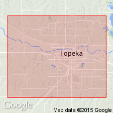
- Forest City basin
Summary:
Pg. 30. Elmont limestone. Very fossiliferous, white or gray argillaceous limestone, 1 to 2 feet thick, found on top of hills near Elmont [Shawnee County, eastern Kansas] and to north. Included in Upper Coal Measures of Shawnee County. [From statement on p. 28 appears to underlie Willard shale and overlie Auburn shale.] Age is Pennsylvanian.
Source: US geologic names lexicon (USGS Bull. 896, p. 679).

- Usage in publication:
-
- Elmont limestone†
- Modifications:
-
- Abandoned
- AAPG geologic province:
-
- Forest City basin
Summary:
Pg. 66, 68, 71. Elmont limestone of Beede is one bed of the unit which Kirk may have meant to call Emporia limestone. It is "Preston" limestone of Condra and Bengston. If Emporia is to be retained it should apply to limestone between Willard shale and Auburn shale, and that definition is adopted in this report. Emporia has priority over Beede's Elmont limestone. [This discards Elmont limestone.]
Source: US geologic names lexicon (USGS Bull. 896, p. 679); GNC KS-NE Pennsylvanian Corr. Chart, sheet 1, Oct. 1936.

- Usage in publication:
-
- Elmont limestone member
- Modifications:
-
- Reinstated
- Revised
- AAPG geologic province:
-
- Forest City basin
- Nemaha anticline
Summary:
Pg. 10. Elmont limestone member of Preston ("Emporia") limestone of Wabaunsee group. Preston ("Emporia") limestone formation underlies Willard shale formation, overlies Auburn shale formation, and is divided into (descending): Elmont limestone, 2 to 5 feet thick; Harveyville shale, 3 to 7 feet thick; and Reading limestone, 3+/- feet thick. Age is Late Pennsylvanian (Virgil).
Source: US geologic names lexicon (USGS Bull. 896, p. 679); GNC KS-NE Pennsylvanian Corr. Chart, sheet 2, Oct. 1936.

- Usage in publication:
-
- Elmont limestone
- Modifications:
-
- Areal extent
- AAPG geologic province:
-
- Forest City basin
Summary:
Pg. 226. Elmont limestone of Wabaunsee group. According to Beede's section Elmont limestone occurs between Auburn shale below and Willard shale above. It appears from study of type sections that the Elmont limestone = "upper Emporia" of authors. In southern Kansas the Elmont is dense, hard, dark-blue limestone very like Reading limestone, but it commonly bears much more closely spaced vertical joints and is typically a single massive bed that weathers light bluish. Is traced from Nebraska across Kansas to northern Oklahoma where it has been included in upper part of Stonebreaker limestone. Thickness 1 to 15 feet. Age is Late Pennsylvanian (Virgil).
Source: US geologic names lexicon (USGS Bull. 896, p. 679); GNC KS-NE Pennsylvanian Corr. Chart, sheet 2, Oct. 1936.
- Usage in publication:
-
- Elmont limestone
- Modifications:
-
- Areal extent
Summary:
Pg. 17. Elmont limestone. Areal extent of formation noted. [Age is Late Pennsylvanian (Virgil).]
Source: US geologic names lexicon (USGS Bull. 1200, p. 1246).

- Usage in publication:
-
- Elmont limestone member*
- Modifications:
-
- Revised
Summary:
Pg. 2274 (fig. 1), 2276. Elmont limestone member of Emporia limestone. Rank reduced to member status in Emporia limestone here recognized and used as originally defined. Overlies Harveyville shale member; underlies Willard shale. Age is Late Pennsylvanian (Virgilian).
Source: US geologic names lexicon (USGS Bull. 1200, p. 1246).
- Usage in publication:
-
- Elmont limestone member*
- Modifications:
-
- Areal extent
- AAPG geologic province:
-
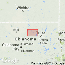
- Chautauqua platform
Summary:
Pg. 58-60. Elmont limestone member of Emporia limestone of Wabaunsee group. Described in Pawnee County, northeastern Oklahoma. As currently defined (Moore, 1949, Kansas Geol. Survey Bull., no. 83), the Elmont overlies Harveyville shale and underlies Willard shale. In Pawnee County, overlying shale is the Gano. Thickness 20 to 34 feet. Traced across Pawnee County, but southern extent not known. [Age is Late Pennsylvanian (Virgil).]
Source: US geologic names lexicon (USGS Bull. 1200, p. 1246).

- Usage in publication:
-
- Elmont limestone
- Modifications:
-
- Areal extent
Summary:
Pg.12-13, fig. 5. Elmont limestone of Wabaunsee group. Underlies Willard shale; overlies Harveyville shale. Consists of two limestone beds separated by fossiliferous gray shale. Upper bed nodular and argillaceous; lower bed, dark blue gray, sublithographic. Thickness about 2 feet. Age is Late Pennsylvanian (Virgilian).
Source: US geologic names lexicon (USGS Bull. 1200, p. 1246).
For more information, please contact Nancy Stamm, Geologic Names Committee Secretary.
Asterisk (*) indicates published by U.S. Geological Survey authors.
"No current usage" (†) implies that a name has been abandoned or has fallen into disuse. Former usage and, if known, replacement name given in parentheses ( ).
Slash (/) indicates name conflicts with nomenclatural guidelines (CSN, 1933; ACSN, 1961, 1970; NACSN, 1983, 2005, 2021). May be explained within brackets ([ ]).