

- Usage in publication:
-
- El Piojo Formation*
- Modifications:
-
- Named
- Biostratigraphic dating
- Dominant lithology:
-
- Sandstone
- Conglomerate
- Mudstone
- AAPG geologic province:
-
- California Coast Ranges province
Summary:
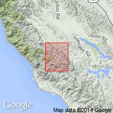
Named for El Piojo Creek, Type locality is sandstone exposed just N of Little Oak Flat (sec 13, T24S, R8E), NE part of Burnett Peak 7.5' quad, Monterey Co, CA. Extends NW through Jolon quad and SE across Bryson quad. Is composed of thick-bedded, gritty, graded sandstone with mappable conglomerate and mudstone with thin-bedded sandstone beds. Has 1300 m exposed thickness in Burnett Peak quad. Base of unit not exposed. Unconformably underlies Piedras Altas Formation. Assigned Maastrichtian age based on foraminifers (spiroplectamnids, W.V. Sliter, written commun., 1985), pollen (Norman Frederiksen, written commun., 1985), and shallow marine fossils of late Maastrichtian age (Saul, 1986).
Source: GNU records (USGS DDS-6; Menlo GNULEX).
For more information, please contact Nancy Stamm, Geologic Names Committee Secretary.
Asterisk (*) indicates published by U.S. Geological Survey authors.
"No current usage" (†) implies that a name has been abandoned or has fallen into disuse. Former usage and, if known, replacement name given in parentheses ( ).
Slash (/) indicates name conflicts with nomenclatural guidelines (CSN, 1933; ACSN, 1961, 1970; NACSN, 1983, 2005, 2021). May be explained within brackets ([ ]).