The National Geologic Map Database is migrating to a new infrastructure. We apologize for any service disruptions during this process.
|
|---|


- Usage in publication:
-
- El Modeno volcanics*
- Modifications:
-
- Original reference
- Dominant lithology:
-
- Basalt
- Tuff
- Andesite
- Breccia
- AAPG geologic province:
-
- Los Angeles basin
Summary:
A series of volcanic rocks. Subdivided into three members: the oldest, an olivine basalt flow; the second, a palagonitic tuff and tuff breccia; and the upper, a calcic andesite flow and flow breccia. Locally one or more of members may be missing. Thickness ranges from about 100 feet to 750 feet; average thickness about 300 feet. Unconformably underlie La Vida member (new) of Puente formation; overlie Topanga formation. Volcanics probably straddle boundary between middle and late Miocene.
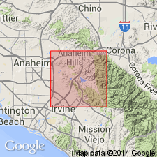
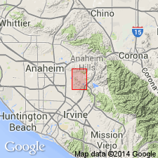
Exposed in hills just east of El Modeno, Orange Co., southern CA. Cover an area of approx. 4 sq mi.
Source: US geologic names lexicon (USGS Bull. 1200, p. 1245-1246).
- Usage in publication:
-
- El Modeno volcanics*
- Modifications:
-
- Areal extent
- AAPG geologic province:
-
- Los Angeles basin
Summary:
Pg. 313-324, pl. 46. Detailed description of unit. Maximum outcrop thickness 850 feet. [Age is] middle to early late Miocene. Tentatively correlated with Glendora volcanics 25 miles to northwest.
Source: US geologic names lexicon (USGS Bull. 1200, p. 1245-1246).
For more information, please contact Nancy Stamm, Geologic Names Committee Secretary.
Asterisk (*) indicates published by U.S. Geological Survey authors.
"No current usage" (†) implies that a name has been abandoned or has fallen into disuse. Former usage and, if known, replacement name given in parentheses ( ).
Slash (/) indicates name conflicts with nomenclatural guidelines (CSN, 1933; ACSN, 1961, 1970; NACSN, 1983, 2005, 2021). May be explained within brackets ([ ]).