

- Usage in publication:
-
- El Cajete flow
- Modifications:
-
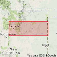
- Areal extent
- AAPG geologic province:
-
- San Juan basin
Summary:
Pg. 53 (fig. 5), 54. El Cajete flow. A post-Bandelier flow. Diagram shows the El Cajete between Battleship Rock flow below and Banco Bonito flows above. [Age is Pleistocene.]
El Cajete is low crater at base of Redondo Mountains, [approx. Lat. 35 deg. 50 min. 12 sec. N., Long. 106 deg. 33 min. 30 sec. W., in T. 19 N., R. 3 E., Redondo Peak 7.5-min quadrangle, in Valles Caldera National Preserve], Jemez Mountains, north-central NM. [Additional locality information from USGS historical topographic map collection TopoView, accessed December 9, 2012.]
Source: US geologic names lexicon (USGS Bull. 1350, p. 237).
- Usage in publication:
-
- El Cajete Member*
- Modifications:
-
- Principal reference
- Revised
- Adopted
- Dominant lithology:
-
- Rhyolite
- Pumice
- AAPG geologic province:
-
- San Juan basin
Summary:
Pg. P17-P18. El Cajete Member of Valles Rhyolite of Tewa Group is adopted by the USGS. Is a mantle-bedded air-fall deposit of rhyolite pumice lapilli and blocks. Maximum thickness about 250 feet. Underlies Banco Bonito Member of Valles Rhyolite. Age is Pleistocene; a charcoal sample collected from a thin ash-flow unit overlying El Cajete pumice was dated as greater than 42,000 yrs B.P. (Meyer Rubin, written commun., 1965).
Named from its source vent, El Cajete crater, which is about 2 mi south of Redondo, [approx. Lat. 35 deg. 50 min. 12 sec. N., Long. 106 deg. 33 min. 30 sec. W., in T. 19 N., R. 3 E., Redondo Peak 7.5-min quadrangle, in Valles Caldera National Preserve, Sandoval Co.], north-central NM. (Pronounced el kah-heh'-teh.) [Additional locality information from USGS historical topographic map collection TopoView, accessed December 9, 2012.]
Source: Publication; Changes in stratigraphic nomenclature, 1969 (USGS Bull. 1324-A, p. A5).
For more information, please contact Nancy Stamm, Geologic Names Committee Secretary.
Asterisk (*) indicates published by U.S. Geological Survey authors.
"No current usage" (†) implies that a name has been abandoned or has fallen into disuse. Former usage and, if known, replacement name given in parentheses ( ).
Slash (/) indicates name conflicts with nomenclatural guidelines (CSN, 1933; ACSN, 1961, 1970; NACSN, 1983, 2005, 2021). May be explained within brackets ([ ]).