The National Geologic Map Database is migrating to a new infrastructure. We apologize for any service disruptions during this process.
|
|---|


- Usage in publication:
-
- Edwardsville formation
- Modifications:
-
- First used
- AAPG geologic province:
-
- Cincinnati arch
Summary:
Writer's studies reveal that the Borden group consists of five geologic formations recognizable throughout the entire area. The formations in order of superposition are the Edwardsville, Floyds Knob, Carwood, St. Joseph, and New Providence. Each formation displays numerous facies.
Source: GNU records (USGS DDS-6; Reston GNULEX).
- Usage in publication:
-
- Edwardsville formation
- Modifications:
-
- Overview
- Dominant lithology:
-
- Shale
- Siltstone
- Sandstone
- AAPG geologic province:
-
- Cincinnati arch
Summary:
The Edwardsville is in many respects the most unique formation in the Borden group. It is the top formation and displays the greatest range in thickness--from 40 to 200 ft. Consists of predominantly shale, siltstone, and sandstone. A calcareous lithology at the extreme southern end of IN outcrop area and in adjacent KY makes it difficult to distinguish from basal member of overlying Harrodsburg limestone. It overlies Floyds Knob formation. Age is Mississippian.
Source: GNU records (USGS DDS-6; Reston GNULEX).
- Usage in publication:
-
- Edwardsville formation
- Modifications:
-
- Named
- AAPG geologic province:
-
- Cincinnati arch
Summary:
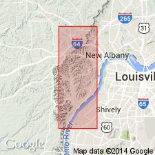
Edwardsville formation in previous writings has been included in "Knob sandstone," "Riverside sandstone," "Knobstone sandstone," and "Warsaw" of Butts (1915, 1918, 1922). It is named for village of Edwardsville, near center of NE1/4 sec. 1, T3S, R5E, 4.5 mi west of New Albany, IN. It is completely exposed in clean-cut association with overlying Harrodsburg limestone and underlying Floyds Knob formation along State Hwy 62, a short distance northeast of Edwardsville, where it is 53 ft thick. Includes the following facies: Stewarts Landing, Springer Knob, Medora Knob, Allens Creek, Bear Wallow, and Riverside sandstone. Named members (not in sequence): Dry Creek sandstone, Brownstone Hills, Cutright sandstone, Weed Patch, and Mount Ebel sandstone. The complex relationships between uppermost Edwardsville and overlying Harrodsburg limestone at extreme southern part of State, and uncertainty as to boundary line between the two units at many places father north, suggest that Ramp Creek member of Harrodsburg might better be included in the Borden group as part of the Edwardsville.
Source: GNU records (USGS DDS-6; Reston GNULEX).
- Usage in publication:
-
- Edwardsville
- Modifications:
-
- Revised
- AAPG geologic province:
-
- Cincinnati arch
Summary:
Locust Point, Carwood, Floyds Knob, and Edwardsville of IN were proposed by this author in 1931. In present report, the Floyds Knob is carried into the KY classification. The Edwardsville and "Lower Harrodsburg" are combined in the Muldraugh formation (new); the Locust Point and Carwood together make the Brodhead formation (new) in KY.
Source: GNU records (USGS DDS-6; Reston GNULEX).
- Usage in publication:
-
- Edwardsville formation
- Modifications:
-
- Revised
- AAPG geologic province:
-
- Cincinnati arch
Summary:
Includes Floyds Knob member (rank reduced).
Source: GNU records (USGS DDS-6; Reston GNULEX).
- Usage in publication:
-
- Edwardsville formation
- Modifications:
-
- Revised
- AAPG geologic province:
-
- Cincinnati arch
Summary:
Shown on correlation chart in Borden group. Underlies Harrodsburg limestone; overlies Floyds Knob formation. Assigned to Osage series.
Source: GNU records (USGS DDS-6; Reston GNULEX).

- Usage in publication:
-
- Edwardsville Formation
- Modifications:
-
- Overview
- AAPG geologic province:
-
- Cincinnati arch
Summary:
The Edwardsville of present usage conformably overlies the Spickert Knob Formation and disconformably underlies the Ramp Creek Formation or the Muldraugh Formation. Above the Floyds Knob Limestone Member, siltstone, sandy shale, and sandstone are the dominant lithologies along most of the outcrop. Top is marked by a bed of glauconite. Unit represents delta-platform sedimentation. Correlates(?) with part of the Keokuk Limestone of the Mississippi Valley based on conodonts and crinoid beds.
Source: GNU records (USGS DDS-6; Reston GNULEX).
For more information, please contact Nancy Stamm, Geologic Names Committee Secretary.
Asterisk (*) indicates published by U.S. Geological Survey authors.
"No current usage" (†) implies that a name has been abandoned or has fallen into disuse. Former usage and, if known, replacement name given in parentheses ( ).
Slash (/) indicates name conflicts with nomenclatural guidelines (CSN, 1933; ACSN, 1961, 1970; NACSN, 1983, 2005, 2021). May be explained within brackets ([ ]).