The National Geologic Map Database is migrating to a new infrastructure. We apologize for any service disruptions during this process.
|
|---|


- Usage in publication:
-
- Edwards Creek Tuff*
- Modifications:
-
- Named
- Geochronologic dating
- Reference
- Dominant lithology:
-
- Tuff
- AAPG geologic province:
-
- Great Basin province
Summary:
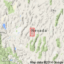
Named for exposures along northeast edge of Edwards Creek Valley (northwest edge of New Pass Range) sec.5 T21N R40E, which is also the type section, northeastern Churchill Co, NV in Great Basin province. Consists of five cooling units of welded and non-welded silicic tuff recognized over a 400 sq mi area; 530 ft thick at type locality, 300 ft thick at reference locality 13 mi east on eastern edge of Antelope Valley sec.36 T23N R41E. Overlies unnamed "lithic eutaxite" with apparent conformity; overlain by biotite-rich tuff of McCoy mine with minor local unconformity. Two K-Ar sanidine ages of 26.9 and 27.0 +/-1 Ma indicate Oligocene or Miocene age.
Source: GNU records (USGS DDS-6; Menlo GNULEX).
For more information, please contact Nancy Stamm, Geologic Names Committee Secretary.
Asterisk (*) indicates published by U.S. Geological Survey authors.
"No current usage" (†) implies that a name has been abandoned or has fallen into disuse. Former usage and, if known, replacement name given in parentheses ( ).
Slash (/) indicates name conflicts with nomenclatural guidelines (CSN, 1933; ACSN, 1961, 1970; NACSN, 1983, 2005, 2021). May be explained within brackets ([ ]).