The National Geologic Map Database is migrating to a new infrastructure. We apologize for any service disruptions during this process.
|
|---|


- Usage in publication:
-
- Edie School rhyolites
- Modifications:
-
- First used
- Dominant lithology:
-
- Rhyolite
- AAPG geologic province:
-
- Montana folded belt
Summary:
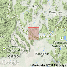
Name applied to some rhyolitic lavas in the South Medicine Lodge basin and in an upthrown fault block of the Tendoy Range near Bannock Pass, Beaverhead Co, MT, Montana folded belt province. Intent to name, source of name, designation of a type locality not stated. Geologic map. Consists of slightly porous, lavender, brown-weathering rhyolitic lavas that have an aphanitic groundmass with glassy phenocrysts. Estimated at 200-250 ft thick. Source may be Yellowstone Park area or a locality in central ID. Considered Pliocene age, younger than Medicine Lodge volcanics (first used) and younger than the Snake River basaltic lavas.
Source: GNU records (USGS DDS-6; Denver GNULEX).
For more information, please contact Nancy Stamm, Geologic Names Committee Secretary.
Asterisk (*) indicates published by U.S. Geological Survey authors.
"No current usage" (†) implies that a name has been abandoned or has fallen into disuse. Former usage and, if known, replacement name given in parentheses ( ).
Slash (/) indicates name conflicts with nomenclatural guidelines (CSN, 1933; ACSN, 1961, 1970; NACSN, 1983, 2005, 2021). May be explained within brackets ([ ]).