The National Geologic Map Database is migrating to a new infrastructure. We apologize for any service disruptions during this process.
|
|---|


- Usage in publication:
-
- Eastland sandstone
- Modifications:
-
- Original reference
- Dominant lithology:
-
- Sandstone
- AAPG geologic province:
-
- Bend arch
Summary:
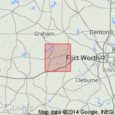
Pg. 62. Eastland sandstone is here defined as first continuous sandstone bed above Home Creek limestone. Is well exposed in RR cut 1+/- mile northwest of Eastland, Eastland County, central Texas, and the main escarpment lies north and northeast of Lake Eastland. It caps escarpments west of Finis in Jack County, and many elevations along Caddo Creek northeast of Cado in Stephens County. Is member of Graham formation, and consists of 10 to 15 feet of dark grayish brown, massively bedded sandstone, thin-bedded at top. Underlies Gonzales Creek shale and overlies Finis shale. [Age is Late Pennsylvanian.]
Source: US geologic names lexicon (USGS Bull. 896, p. 655).
For more information, please contact Nancy Stamm, Geologic Names Committee Secretary.
Asterisk (*) indicates published by U.S. Geological Survey authors.
"No current usage" (†) implies that a name has been abandoned or has fallen into disuse. Former usage and, if known, replacement name given in parentheses ( ).
Slash (/) indicates name conflicts with nomenclatural guidelines (CSN, 1933; ACSN, 1961, 1970; NACSN, 1983, 2005, 2021). May be explained within brackets ([ ]).