The National Geologic Map Database is migrating to a new infrastructure. We apologize for any service disruptions during this process.
|
|---|


- Usage in publication:
-
- East End Member
- Modifications:
-
- Named
- Dominant lithology:
-
- Tuff
- Mudstone
- Breccia
- Sandstone
- AAPG geologic province:
-
- Caribbean region
Summary:
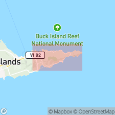
Named for East End Range, eastern St. Croix, VI. Occurs as a narrow band between Shoy Point on the northern coast and Isaac Point on the southern coast. Three subdivisions are recognized at Isaac Point, Grass Point, and Hughes Point. From oldest to youngest, unit consists of volcanic breccia and tuffaceous sandstone, 175 ft thick; black mudstone, 200 ft thick; and light-green, coarse-grained, tuffaceous sandstone at least 300 ft thick. West of Grass Point, mudstone part thins to feather edge; volcanic breccia decreases to only 5 to 10 percent. To the northwest, around Shoy Point, unit is metamorphosed. Total thickness is 900 ft. Occurs 3,000 ft below top of Caledonia Formation. Report includes geologic map and correlation diagrams. Age is Late Cretaceous.
Source: GNU records (USGS DDS-6; Reston GNULEX).
- Usage in publication:
-
- East End Member
- Modifications:
-
- Biostratigraphic dating
- Geochronologic dating
- AAPG geologic province:
-
- Caribbean region
Summary:
East End Member of Whetten (1966) used in this report. Late Cretaceous (Campanian and Maastrichtian(?)) age determined by fossils and date of dikes (74-64 m.y.).
Source: GNU records (USGS DDS-6; Reston GNULEX).
- Usage in publication:
-
- East End Member*
- Modifications:
-
- Geochronologic dating
- AAPG geologic province:
-
- Caribbean region
Summary:
Table 1 indicates a K-Ar date of 75.2+/-4.3 m.y., which is Campanian; however, the table states that it is early Campanian to mid-Santonian in age.
Source: GNU records (USGS DDS-6; Reston GNULEX).
For more information, please contact Nancy Stamm, Geologic Names Committee Secretary.
Asterisk (*) indicates published by U.S. Geological Survey authors.
"No current usage" (†) implies that a name has been abandoned or has fallen into disuse. Former usage and, if known, replacement name given in parentheses ( ).
Slash (/) indicates name conflicts with nomenclatural guidelines (CSN, 1933; ACSN, 1961, 1970; NACSN, 1983, 2005, 2021). May be explained within brackets ([ ]).