

- Usage in publication:
-
- Ear Peak Member*
- Modifications:
-
- Named
- Biostratigraphic dating
- Dominant lithology:
-
- Conglomerate
- Sandstone
- Shale
- AAPG geologic province:
-
- Alaska Northern region
Summary:
Name proposed for the lowermost member (of 3) of Kanayut Conglomerate. Extends across almost all of eastern and central Brooks Range. Consists of fluvial conglomerate, sandstone, and shale as thick as 1160 m. Gradationally overlies Hunt Fork Shale or intervening Noatak Sandstone. Gradationally underlies Shainin Lake Member (new) of Kanayut Conglomerate. Age is Late Devonian, based plant fossils within unit and marine fossils in underlying Noatak Sandstone and Hunt Fork Shale.
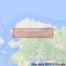
Type section: measured along ridge 1.8 km southeast of Ear Peak (several km east of Shainin Lake), in secs. 13 and 24, T. 13 S., R. 5 E., and in sec. 18, T. 13 S., R. 6 E., Chandler Lake quadrangle, northern AK. Named from exposures near Ear Peak.
Source: Modified from GNU records (USGS DDS-6; Menlo GNULEX).
For more information, please contact Nancy Stamm, Geologic Names Committee Secretary.
Asterisk (*) indicates published by U.S. Geological Survey authors.
"No current usage" (†) implies that a name has been abandoned or has fallen into disuse. Former usage and, if known, replacement name given in parentheses ( ).
Slash (/) indicates name conflicts with nomenclatural guidelines (CSN, 1933; ACSN, 1961, 1970; NACSN, 1983, 2005, 2021). May be explained within brackets ([ ]).