The National Geologic Map Database is migrating to a new infrastructure. We apologize for any service disruptions during this process.
|
|---|


- Usage in publication:
-
- Eagle Mills formation
- Modifications:
-
- Named
- Dominant lithology:
-
- Shale
- Anhydrite
- Salt
- AAPG geologic province:
-
- Arkla basin
Summary:
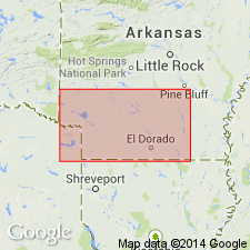
Is a subsurface unit named for redbeds, salt, and anhydrite above Pennsylvanian black shale and slates and unconformably? below the Smackover limestone (first? used). Named for the Amerada Petroleum Co. Eagle Mills No. 1, sec 11, T12S, R16W, just north of town of Eagle Mills, Ouachita Co, AR in the Arkla basin where the formation is 1,190 ft thick. Red shale present at base. Some gray shale, a few streaks of red argillaceous sand and red argillaceous dolomite in lower part. Clear, crystalline white anhydrite known at two wells. Pure, except for a few partings of white gypsum, crystalline salt at top. Is separated from overlying Smackover by approx. 40 ft of red, argillaceous sand and sandy shale. Cross section, columnar section. The salt is 1,325 ft thick on the Norphlet dome and only 850 ft thick at Louann. Pinches out in north somewhere between Louann, Union Co, AR and Camden, Ouachita Co, AR. Assigned a Permian? age.
Source: GNU records (USGS DDS-6; Denver GNULEX).
- Usage in publication:
-
- Eagle Mills Formation
- Modifications:
-
- Overview
- AAPG geologic province:
-
- Mid-Gulf Coast basin
Summary:
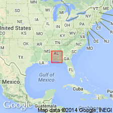
In this report, all Triassic to Lower Jurassic(?) sedimentary rocks in AL are referred to as the Eagle Mills Formation. Unit is contained in a system of grabens and half grabens that extends in the subsurface of the Gulf Coastal Plain from TX to AL. Most Eagle Mills rocks penetrated in AL are lithologically similar to those in AR in that they are primarily red shale or mudstone, mottled locally with green and gray and are locally finely micaceous, calcareous, or dolomitic. Underlies Werner Formation (Middle Jurassic) or Norphlet or Haynesville Formations (Upper Jurassic).
Source: GNU records (USGS DDS-6; Reston GNULEX).
For more information, please contact Nancy Stamm, Geologic Names Committee Secretary.
Asterisk (*) indicates published by U.S. Geological Survey authors.
"No current usage" (†) implies that a name has been abandoned or has fallen into disuse. Former usage and, if known, replacement name given in parentheses ( ).
Slash (/) indicates name conflicts with nomenclatural guidelines (CSN, 1933; ACSN, 1961, 1970; NACSN, 1983, 2005, 2021). May be explained within brackets ([ ]).