

- Usage in publication:
-
- Duperow formation*
- Modifications:
-
- Principal reference
- Revised
- Dominant lithology:
-
- Limestone
- Dolomite
- Anhydrite
- AAPG geologic province:
-
- Central Montana uplift
- Powder River basin
- Williston basin
Summary:
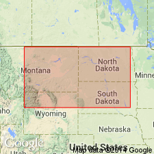
Pg. 2299 (fig. 2), 2302-2304 (fig. 4), 2309 (fig. 5), 2315-2318, 2319 (fig. 6). Duperow formation of Jefferson group. Named by Powley (unpub. thesis, 1951). He designated type subsurface section as interval between depths of 3,310 and 4,150 feet in Tidewater Oil Company's Duperow Crown No. 1 well in southwestern Saskatchewan, Canada, and considered the Duperow to be equivalent to all but basal section of Beaverhill Lake formation of Late Devonian age in Alberta, Canada. In February 1953, Williston Basin Nomenclature Committee of AAPG abandoned use of Duperow formation in sense in which Powley had originally intended and applied name to overlying lithologic unit. The Duperow as defined by the committee has been used widely in geologic literature and by geologists working in Williston basin. Standard subsurface section herein designated. Consists of medium- to brownish-gray, dense to microcrystalline limestone, yellowish- to light-brownish-gray, fine-grained, argillaceous limestone and dolomitic limestone, brownish-gray, finely crystalline dolomite, and white to brownish-gray anhydrite, interbedded with thinner beds of greenish-gray, dolomitic shale, very fine-grained siltstone, and sandy argillaceous dolomite. Formation ranges in thickness from fraction of a foot to approximately 600 feet in north-central and northeastern Montana along International Boundary. Is the basal formation of Jefferson group. Overlies Souris River formation; underlies Birdbear formation (new). Present in subsurface of North Dakota, northeastern Montana, and northwestern South Dakota, and Manitoba and Saskatchewan, Canada. [Fossils (brachiopods).] Age is Late Devonian.
Standard section: depth-interval 10,400 to 10,743 feet, Mobil Producing Comapany Birdbear No. 1 well, in center sec. 22, T. 149 N., R. 91 W., Dunn Co., ND.
Source: US geologic names lexicon (USGS Bull. 1200, p. 1183-1184).
For more information, please contact Nancy Stamm, Geologic Names Committee Secretary.
Asterisk (*) indicates published by U.S. Geological Survey authors.
"No current usage" (†) implies that a name has been abandoned or has fallen into disuse. Former usage and, if known, replacement name given in parentheses ( ).
Slash (/) indicates name conflicts with nomenclatural guidelines (CSN, 1933; ACSN, 1961, 1970; NACSN, 1983, 2005, 2021). May be explained within brackets ([ ]).