The National Geologic Map Database is migrating to a new infrastructure. We apologize for any service disruptions during this process.
|
|---|


- Usage in publication:
-
- Dunkleberg member
- Modifications:
-
- Named
- Dominant lithology:
-
- Mudstone
- Siltstone
- Sandstone
- Conglomerate
- AAPG geologic province:
-
- Montana folded belt
Summary:
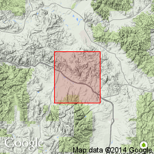
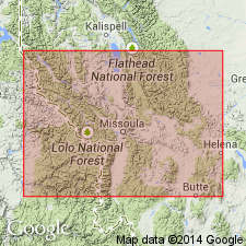
Named as upper member of Blackleaf formation of Colorado group for Dunkleberg Ridge and Creek, Powell Co, MT, Montana folded belt province. Type section is in an unnamed gulch-network which drains low hills on southwest side of Saddle Mountain in E1/2 sec 8, T10N, R11W. Includes 1,700 ft of mudstone, siltstone, and sandstone, and several thick conglomerate beds. Alteration of volcanic-rich strata has caused extensive silification. The numerous light-gray, white, and tan porcellanite and siliceous siltstone beds form light bands easily recognized on aerial photographs. Lower contact placed at base of massive lenticular chert-pebble conglomerates and salt-and-pepper sandstones of Dunkleberg with Taft Hill member of Blackleaf [lithologic description of contact not stated], a disconformable contact. Upper contact with limestone and sandstone of Coberly formation (new) is a sharp disconformity. [Lithologic description not clearly stated]. Is the western equivalent of the Vaughn bentonitic member and Bootlegger member of Blackleaf. Of Cretaceous age.
Source: GNU records (USGS DDS-6; Denver GNULEX).
- Usage in publication:
-
- Dunkleberg Member
- Modifications:
-
- Not used
Summary:
Not used in Drummond area, Granite Co, MT, Montana folded belt province. Blackleaf was divided into, ascending, Flood Shale, Taft Hill, and Dunkleberg Members by Gwinn (1961). Mapping by Wallace and others (1986, USGS Open-File Report 86-292) showed: 1) some of rocks grouped with Taft Hill by Gwinn belong in lower part of Vaughn Member; 2) conglomerate and sandstone at base of Dunkleberg are medial sandstone and conglomerate of Vaughn; and 3) Taft Hill is commonly absent below Vaughn.
Source: GNU records (USGS DDS-6; Denver GNULEX).
For more information, please contact Nancy Stamm, Geologic Names Committee Secretary.
Asterisk (*) indicates published by U.S. Geological Survey authors.
"No current usage" (†) implies that a name has been abandoned or has fallen into disuse. Former usage and, if known, replacement name given in parentheses ( ).
Slash (/) indicates name conflicts with nomenclatural guidelines (CSN, 1933; ACSN, 1961, 1970; NACSN, 1983, 2005, 2021). May be explained within brackets ([ ]).