


- Usage in publication:
-
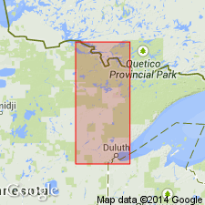
- Duluth Complex*
- Modifications:
-
- Overview
- AAPG geologic province:
-
- Lake Superior region
Summary:
Present in northeast MN in Lake Superior region. Part of mafic plutonic rocks mapped together with Beaver Bay Complex in the vicinity of the north shore of Lake Superior. Intrudes North Shore Volcanic Group. Isotopic ages indicate emplacement around 1,100 m.y., or during the Middle Proterozoic. Correlation chart.
Source: GNU records (USGS DDS-6; Reston GNULEX).
- Usage in publication:
-
- Duluth Complex
- Modifications:
-
- Overview
- AAPG geologic province:
-
- Sioux uplift
Summary:
Rocks of the Duluth Complex are generally divided into an older anorthositic series and a younger troctolitic series. Three large intrusive bodies have been described by Foose and Weiblen (1986) within the troctolitic series: South Kawishiwi intrusion, Partridge River intrusion; and the Bald Eagle intrusion. Study area of this report is located at the northwestern contact of the Partridge River intrusion. The footwall of the Partridge River intrusion consists of shallow dipping, Middle Precambrian (1.7 b.y.) metasediments of the Animikie Group.
Source: GNU records (USGS DDS-6; Reston GNULEX).
- Usage in publication:
-
- Duluth Complex
- Modifications:
-
- Overview
- AAPG geologic province:
-
- Sioux uplift
Summary:
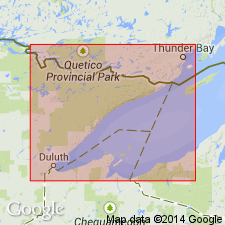
Described as a thick, wedge-shaped body of gabbro, troctolite, and anorthosite up to 15 km thick. Complex was emplaced into the Midcontinent Rift system beneath the Keweenawan North Shore Volcanic Group approximately 1.1 Ga. The Partridge River Intrusion is one of several troctolitic intrusions on the northwestern margin of the Duluth complex that contain Cu-Ni sulfides adjacent to the footwall rocks. Crystal-liquid mixture of Partridge River was modified after emplacement by assimilation of footwall Virginia Formation.
Source: GNU records (USGS DDS-6; Reston GNULEX).
- Usage in publication:
-
- Duluth Complex*
- Modifications:
-
- Geochronologic dating
- AAPG geologic province:
-
- Lake Superior region
Summary:
High precision U-Pb ages on zircons from anorthositic and gabbroic rocks indicate an age of 1106.9 +/-0.6 Ma for a series of layered gabbroic cumulates (Nathan's layered series) which represents earliest activity in Duluth Complex. Age of bulk of Duluth anorthositic and troctolitic rocks dated by four samples range from 1099.3 +/-0.3 to 1098.6 +/-0.5 Ma. Duluth rocks are associated with 1100 Ma (Keweenawan) Midcontinent Rift system in Lake Superior area, Lake Superior region. Duluth slightly older than Beaver Bay Complex dated at about 1096 Ma. Generalized geologic maps (figs. 1, 3); correlation chart with absolute ages (fig. 2).
Source: GNU records (USGS DDS-6; Denver GNULEX).
For more information, please contact Nancy Stamm, Geologic Names Committee Secretary.
Asterisk (*) indicates published by U.S. Geological Survey authors.
"No current usage" (†) implies that a name has been abandoned or has fallen into disuse. Former usage and, if known, replacement name given in parentheses ( ).
Slash (/) indicates name conflicts with nomenclatural guidelines (CSN, 1933; ACSN, 1961, 1970; NACSN, 1983, 2005, 2021). May be explained within brackets ([ ]).