The National Geologic Map Database is migrating to a new infrastructure. We apologize for any service disruptions during this process.
|
|---|


- Usage in publication:
-
- Dugout clays and gravels
- Modifications:
-
- First used
- Dominant lithology:
-
- Clay
- Silt
- Sand
- Gravel
- AAPG geologic province:
-
- Permian basin
Summary:
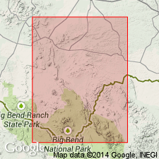
First used to describe 1-300 ft of clay, silt, sand, and gravel of a reddish color on west side of Tornillo Creek and northwest of Boquillas, southern Brewster Co, TX in Permian basin. Occurs in an oval area about 12 mi long and 4 mi wide with long axis extending from northwest to southeast. Overlies sediments of Cretaceous age. Finer sediments constitute greater bulk of formation as seen along road to the Dugout wells from Boquillas. Is mostly gravel in Rice's Canyon a few mi to north. Formation rises in a flat ridge extending northwestward from the Dugout wells. Finer sediments resemble Equus beds of the Great Plains and also the Pleistocene river silts in valley of the Rio Grande. No fossils found, but overlies post-volcanic topography. May be old alluvial drift deposited by Tornillo Creek. Age shown as Miocene and Pliocene on unnumbered table (p. 17).
Source: GNU records (USGS DDS-6; Denver GNULEX).
For more information, please contact Nancy Stamm, Geologic Names Committee Secretary.
Asterisk (*) indicates published by U.S. Geological Survey authors.
"No current usage" (†) implies that a name has been abandoned or has fallen into disuse. Former usage and, if known, replacement name given in parentheses ( ).
Slash (/) indicates name conflicts with nomenclatural guidelines (CSN, 1933; ACSN, 1961, 1970; NACSN, 1983, 2005, 2021). May be explained within brackets ([ ]).