

- Usage in publication:
-
- Duarte conglomerate*
- Modifications:
-
- Original reference
- Dominant lithology:
-
- Conglomerate
- AAPG geologic province:
-
- Los Angeles basin
Summary:
Coarse unsorted sandy poorly consolidated conglomerate; conspicuously gray and light colored. Maximum exposed thickness at least 1,500 feet, due north of Duarte, where it either overlies or is faulted against sandstone of Topanga(?) formation, and is overlain by Quaternary deposits. Age is Pliocene(?).
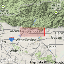
Exposed in steeply dipping, isolated outcrops, in foothills between Maddock and Sawpit Canyons, north and northwest of town of Duarte, east of Monrovia, Los Angeles Co., southern CA.
Source: US geologic names lexicon (USGS Bull. 1200, p. 1167).
For more information, please contact Nancy Stamm, Geologic Names Committee Secretary.
Asterisk (*) indicates published by U.S. Geological Survey authors.
"No current usage" (†) implies that a name has been abandoned or has fallen into disuse. Former usage and, if known, replacement name given in parentheses ( ).
Slash (/) indicates name conflicts with nomenclatural guidelines (CSN, 1933; ACSN, 1961, 1970; NACSN, 1983, 2005, 2021). May be explained within brackets ([ ]).