

- Usage in publication:
-
- Dry Creek Volcanics
- Modifications:
-
- Named
- Dominant lithology:
-
- Breccia
- Andesite
- Mudflow
- AAPG geologic province:
-
- Modoc Plateau province
- Great Basin province
Summary:
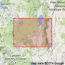
Ring dike and vent breccia of unit are exposed in Dry Creek Basin, in secs. 2 and 3, T. 42 N., R. 14 E., southeastern quarter of Davis Creek 15-min quadrangle. Dry Creek Volcanics consist of airfall andesite breccias, minor mud-flow breccias and andesite flows with thin localized dense basalts. Field characteristics include dark pumiceous tuffs with numerous breadcrust and cow dung bombs. Dry Creek volcano became active in Oligocene prior to major uplift of Warner Range. Age of units in study area (Warner Mountains) is Tertiary.
Derivation of name not stated, but probably named from Dry Creek or Dry Creek Basin in Davis Creek 15-min quadrangle, northeast CA.
Source: Modified from GNU records (USGS DDS-6; Menlo GNULEX).
For more information, please contact Nancy Stamm, Geologic Names Committee Secretary.
Asterisk (*) indicates published by U.S. Geological Survey authors.
"No current usage" (†) implies that a name has been abandoned or has fallen into disuse. Former usage and, if known, replacement name given in parentheses ( ).
Slash (/) indicates name conflicts with nomenclatural guidelines (CSN, 1933; ACSN, 1961, 1970; NACSN, 1983, 2005, 2021). May be explained within brackets ([ ]).