

- Usage in publication:
-
- Dry Creek Canyon member*
- Modifications:
-
- Named
- Dominant lithology:
-
- Sandstone
- Clay
- AAPG geologic province:
-
- Denver basin
Summary:
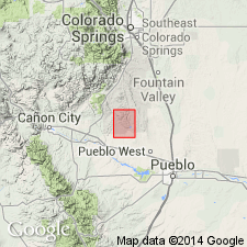
Named as middle member of Dakota sandstone for Dry Creek Canyon, Pueblo Co, CO in Denver basin. Type area measured in S1/2 NW1/4 SE1/4 sec 26, T18S, R67W where it is 55 ft thick. At type is composed of: 1) gray to white, fine- to medium-grained, even-bedded compact sandstone intercalated with thin layers of carbonaceous shale, gray siltstone and sandy shale at base; 2) middle gray to black clay; 3) upper soft white to hard green, fine-grained, thin- to thick-bedded sandstone and intercalated gray sandy clay. Carbonaceous matter in upper unit. Plant remains in basal and upper unit. Disconformably overlies lower sandstone unit of Dakota; disconformably underlies upper sandstone unit of Dakota. About four-fifths of the area where Dakota is exposed in eastern Fremont and western Pueblo, Denver basin, and northeastern Huerfano, Las Vegas-Raton basin (figure 8), the Dry Canyon is missing. Was eroded by channeling prior to deposition of upper sandstone unit. Shown as Early Cretaceous age.
Source: GNU records (USGS DDS-6; Denver GNULEX).
- Usage in publication:
-
- Dry Creek Canyon Member*
- Modifications:
-
- Areal extent
- AAPG geologic province:
-
- Denver basin
Summary:
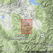
Recognized but not mapped in the middle part of the Dakota Sandstone. Dakota mapped with the underlying Purgatoire Formation in the northeast and north-central parts of the quad in the Webster Park graben, Eightmile Park, and along the east border of the quad in Fremont Co, CO in the Denver basin. Underlying and overlying parts of the Dakota are unnamed. Of Early Cretaceous age.
Source: GNU records (USGS DDS-6; Denver GNULEX).
For more information, please contact Nancy Stamm, Geologic Names Committee Secretary.
Asterisk (*) indicates published by U.S. Geological Survey authors.
"No current usage" (†) implies that a name has been abandoned or has fallen into disuse. Former usage and, if known, replacement name given in parentheses ( ).
Slash (/) indicates name conflicts with nomenclatural guidelines (CSN, 1933; ACSN, 1961, 1970; NACSN, 1983, 2005, 2021). May be explained within brackets ([ ]).