

- Usage in publication:
-
- Drum Mountains Rhyodacite*
- Modifications:
-
- Named
- Dominant lithology:
-
- Rhyodacite
- Sandstone
- Lahar
- AAPG geologic province:
-
- Great Basin province
Summary:
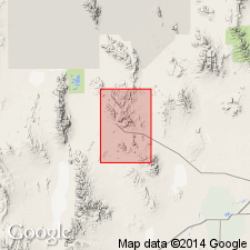
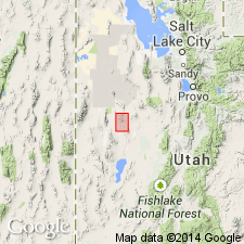
Named for the Drum Mountains, Juab Co, UT. Type locality designated in secs 32, 33, and 34, T14S, R11W. Located in the Great Basin province. Overlies Paleozoic rocks. Composed of rusty-weathering, black rhyodacite flow and breccia. Also has some interbedded tuffaceous sandstone and laharic debris flows. Has a fission-track date of 4l.8 +/-2.3 m.y. or is of late Eocene age. Is older than an unnamed diorite of Eocene age.
Source: GNU records (USGS DDS-6; Denver GNULEX).
- Usage in publication:
-
- Drum Mountains Rhyodacite*
- Modifications:
-
- Overview
- AAPG geologic province:
-
- Great Basin province
Summary:
Is 240 m thickness in Black Hills. Unconformably overlies Paleozoic rocks everywhere; underlies at different localities the Mt. Laird Tuff, Joy Tuff, landslide breccia, Dell Tuff, and Spor Mountain Formation around Spor Mountain. Is located in the Great Basin province. Of late Eocene age--about 42 m.y.
Source: GNU records (USGS DDS-6; Denver GNULEX).
For more information, please contact Nancy Stamm, Geologic Names Committee Secretary.
Asterisk (*) indicates published by U.S. Geological Survey authors.
"No current usage" (†) implies that a name has been abandoned or has fallen into disuse. Former usage and, if known, replacement name given in parentheses ( ).
Slash (/) indicates name conflicts with nomenclatural guidelines (CSN, 1933; ACSN, 1961, 1970; NACSN, 1983, 2005, 2021). May be explained within brackets ([ ]).