The National Geologic Map Database is migrating to a new infrastructure. We apologize for any service disruptions during this process.
|
|---|


- Usage in publication:
-
- Dozier beds
- Dozier sandstones
- Modifications:
-
- Original reference
- Dominant lithology:
-
- Sandstone
- AAPG geologic province:
-
- Palo Duro basin
Summary:
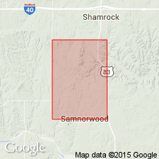
Pg. 142+. [Discusses fossils collected from Whitehorse sandstone of Oklahoma and from Quatermaster formation, and says:] The fossils collected from Quatermaster division of the Permian are from the sandstone rolled down on western side of "Dozier Mountains," east of Mr. Caperton's place (then Dozier Post Office), 15 miles south or southwest of Shamrock, [Collingsworth Co.], in Panhandle of Texas. [Fossils discussed. Mentioned "the gastropods of the Dozier beds" on p. 143, and farther along on same page mentions one species "from the Whitehorse and Dozier sandstones." Under the fossil description the different species are not assigned to any formation but are said to have been collected at Dozier, Texas. All there is about the Dozier sandstone.]
Source: US geologic names lexicon (USGS Bull. 896, p. 629-630).
- Usage in publication:
-
- [Dozier sandstone member]
- Modifications:
-
- Not used
- AAPG geologic province:
-
- Anadarko basin
- Palo Duro basin
- Permian basin
Summary:
Pg. 703. Believes Memphis sandstone is a continuation of Dozier Hills, which are channel deposits, and that it marks base of his Custer formation, which he assigned to Lower Triassic.
Source: US geologic names lexicon (USGS Bull. 896, p. 629-630).

- Usage in publication:
-
- Dozier sandstone member
- Modifications:
-
- Overview
- AAPG geologic province:
-
- Anadarko basin
- Palo Duro basin
- Permian basin
Summary:
Pg. 180. Eskota gypsum, Dozier sandstone, and Claytonville dolomite are members of Whitehorse-Cloud Chief interval (Permian).
Source: US geologic names lexicon (USGS Bull. 896, p. 629-630).
- Usage in publication:
-
- Dozier sandstone member*
- Modifications:
-
- Areal extent
Summary:
[Darton, 1932 USGS Geol. Map of Texas, Prelim. Ed.] Peacock formation, red sandstone. Dozier ("Memphis") sandstone member [which he separately mapped].
[See under †Memphis sandstone.]
Source: US geologic names lexicon (USGS Bull. 896, p. 629-630).
- Usage in publication:
-
- Dozier sandstone member*
- Modifications:
-
- Revised
Summary:
Pl. 2. Dozier sandstone member of Rush Springs formation. Reallocated to member status in Rush Springs formation. [Age is Permian.]
[GNC remark (ca. 1966, US geologic names lexicon, USGS Bull. 1200, p. 1154): The USGS has abandoned the term Peacock.]
Source: US geologic names lexicon (USGS Bull. 1200, p. 1154).
For more information, please contact Nancy Stamm, Geologic Names Committee Secretary.
Asterisk (*) indicates published by U.S. Geological Survey authors.
"No current usage" (†) implies that a name has been abandoned or has fallen into disuse. Former usage and, if known, replacement name given in parentheses ( ).
Slash (/) indicates name conflicts with nomenclatural guidelines (CSN, 1933; ACSN, 1961, 1970; NACSN, 1983, 2005, 2021). May be explained within brackets ([ ]).