The National Geologic Map Database is migrating to a new infrastructure. We apologize for any service disruptions during this process.
|
|---|


- Usage in publication:
-
- Double Mountain beds
- Modifications:
-
- Original reference
- Dominant lithology:
-
- Sandstone
- Shale
- Limestone
- Clay
- Gypsum
- AAPG geologic province:
-
- Bend arch
- Permian basin
Summary:
Pg. 187, 188, and E.T. Dumble's pl. 3 [table of formations facing p. xxx] and p. lxx. Double Mountain beds. Gypsum, rock salt, sands, clays, sandstones, shales, and limestones. Top formation of Permian. Conformably overlies Clear Fork beds and unconformably underlies Dockum beds. Present in central northern and central Texas. Age is Permian.
[Named from Double Mountains, Stonewall Co., central northern TX.]
Source: US geologic names lexicon (USGS Bull. 896, p. 625).
- Usage in publication:
-
- Double Mountain beds
- Modifications:
-
- Revised
- AAPG geologic province:
-
- Permian basin
Summary:
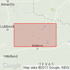
Double Mountain beds revised locally. Present in two measured sections in central northern and central Texas: (1) along the Texas and Pacific RR, from Abilene, Taylor County, to Sweetwater, Nolan County, where it includes Blowout Mountain sandstone, Quartermaster formation, and Lake Trammel sandstone; and (2) 30 mi north of RR, along Double Mountain Fork of Brazos River, from Flat Top Mountain, Haskell County, to top of Double Mountains, Stonewall County, where it includes Blowout Mountain sandstone, Greer formation, and Aspermont dolomite. Overlies Clear Fork beds; underlies Triassic beds. Age is Permian.
Source: Publication; US geologic names lexicon (USGS Bull. 896, Aspermont p. 83, Blowout Mountain p. 216, Lake Trammel p. 1137).
- Usage in publication:
-
- Double Mountain group†
- Modifications:
-
- Abandoned
- AAPG geologic province:
-
- Permian basin
Summary:
Pg. 668. †Double Mountain group abandoned; part of former unit now classed under Whitehorse group. Age is Permian.
Source: US geologic names lexicon (USGS Bull. 1200, p. 1147).

- Usage in publication:
-
- Double Mountain Group
- Modifications:
-
- Reinstated
- AAPG geologic province:
-
- Bend arch
- Permian basin
Summary:
[Term Double Mountain Group was abandoned by King (1942), as well as by subsequent workers. In this report, author "reinstates" term--however, he does not mention the fact that the term was previously abandoned, nor does he indicate intent to reinstate.] Double Mountain Group is the uppermost group of Permian-aged rocks of north-central TX. Rocks of this group crop out in a north to southwest-trending pattern in Taylor and Runnels Cos (Bend arch) and Nolan, Mitchell, Coke, and Sterling Cos (Permian basin). Basically following Sellards (1932), author divides Double Mountain into (ascending): San Angelo, Blaine, and Whitehorse-Cloud Chief-Quartermaster Formations [Sellards also recognized Peacock Formation of Patton (1930) as an alternate name for Whitehorse-Cloud Chief-Quartermaster]. Double Mountain Group overlies the Permian Clear Fork Group and underlies the Triassic Dockum Group. Double Mountain and overlying Dockum have eroded to form the badland-type topography typical of red beds containing siltstones, sands, and conglomerates. Of Permian age. Stratigraphic chart.
Source: GNU records (USGS DDS-6; Denver GNULEX).
For more information, please contact Nancy Stamm, Geologic Names Committee Secretary.
Asterisk (*) indicates published by U.S. Geological Survey authors.
"No current usage" (†) implies that a name has been abandoned or has fallen into disuse. Former usage and, if known, replacement name given in parentheses ( ).
Slash (/) indicates name conflicts with nomenclatural guidelines (CSN, 1933; ACSN, 1961, 1970; NACSN, 1983, 2005, 2021). May be explained within brackets ([ ]).