The National Geologic Map Database is migrating to a new infrastructure. We apologize for any service disruptions during this process.
|
|---|


- Usage in publication:
-
- Dotsero dolomite
- Modifications:
-
- Original reference
- Dominant lithology:
-
- Dolomite
- Limestone
- Shale
- AAPG geologic province:
-
- Eagle basin
Summary:
Pg. 1855-1858. Dotsero dolomite. Gray dolomite and limestone with partings and thin beds of shale. Some beds intraformational conglomerates and breccias. In some beds, the included pebbles are gray, whereas in others they are red. Dolomites and limestones are of shallow-water origin as indicated by presence of ripple marks, rain prints, and other markings. Thickness in a bluff along road, 2.35 miles west of Garfield-Eagle County line, is 269 feet. Conformably overlies Sawatch quartzite and disconformably underlies Parting quartzite member of Chaffee formation. Fossils (graptolites). Beds near top yielded DENDROGRAPTUS EDWARDSII, D. HALLIANUS, and DICTYONEMA COLORADOENSE; beds in lower part yielded DENDROGRAPTUS EDWARDSII, D. HALLIANUS, D. cf. D. THOMASI, CYRTOGRAPTUS BASSETTI, CONOGRAPTUS SIMPLEX, PTIOGRAPTUS COLORADOENSIS, and DICTYONEMA COLORADOENSE. Age is considered Late Cambrian.
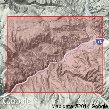
Named from good exposures in northeastern end of Glenwood Canyon near Dotsero, [Dotsero 7.5-min quadrangle], Eagle Co., central northwestern CO; about 100 mi west of Denver. [Additional locality information from USGS historical topographic map collection TopoView, accessed May 14, 2018.]
Source: Publication; US geologic names lexicon (USGS Bull. 1200, p. 1146).
- Usage in publication:
-
- Dotsero formation*
- Modifications:
-
- Revised
- Overview
- AAPG geologic province:
-
- Piceance basin
Summary:
Stratigraphically restricted to the lower part of Dotsero of Bassett (1939). Upper part of Bassett's Dotsero reassigned to the Manitou formation. As revised, Dotsero includes 96 to 106 ft of rock divisible into a lower member named Glenwood Canyon member and an upper member named Clinetop algal limestone member. Glenwood Canyon consists of tan to gray dolomite and a few thin beds of flat-pebble dolomite conglomerate with thin beds of gray dolomitic shale. Clinetop is a ledge-forming algal limestone and conglomerate. Cross section. Measured section. Overlies Sawatch quartzite. Fossils--graptolites, trilobites, alga, pelmatozoans, brachiopods of Trempealeau or Late Cambrian age. [Bassett's 1939 Dotsero was revised apparently because it contained rocks of Late Cambrian age (Dotsero revised) and rocks of Early Ordovician age (Manitou Formation).]
Source: GNU records (USGS DDS-6; Denver GNULEX).
- Usage in publication:
-
- Dotsero Formation
- Modifications:
-
- Revised
- AAPG geologic province:
-
- Piceance basin
Summary:
Name Horseshoe Mountain Group applied to rocks of the Sauk sequence in central CO of Late Cambrian and Early Ordovician age. In its northwest province near Glenwood Springs, Garfield Co in the Piceance basin, the group is divided into the Sawatch Sandstone, Dotsero Formation (and its Glenwood Canyon and Clinetop Members), and Manitou Limestone (and its Deadhorse and Tie Gulch Members). In its southeast province--near Salida, Gunnison Co in the Piceance basin, Colorado Springs, El Paso CO in the Denver basin, and Fairplay, Park Co in the South Park basin--the group is divided into the Sawatch Sandstone, Peerless Formation, and Manitou Limestone (and its Helena Canyon, Ptarmigan (provisional), and Fairplay (provisional) Members). The group is named for exposures on Horseshoe Mountain (the type section) near Fairplay in Park Co. Rocks of the group include conglomerate, sandstone, shale, limestone, and dolomite. Correlation chart. Thickness of group at type (southeast facies--sec. 12, T. 10 S., R. 79 W.) is 352 ft: Manitou, 167 ft; Peerless, 35 ft; and Sawatch, 150 ft. Thickness of group in northwest facies (sec. 15, T. 5 S., R. 87 W.) is 772 ft: Manitou, 156 ft; Dotsero, 96 ft; and Sawatch, 520 ft.
Source: GNU records (USGS DDS-6; Denver GNULEX).
For more information, please contact Nancy Stamm, Geologic Names Committee Secretary.
Asterisk (*) indicates published by U.S. Geological Survey authors.
"No current usage" (†) implies that a name has been abandoned or has fallen into disuse. Former usage and, if known, replacement name given in parentheses ( ).
Slash (/) indicates name conflicts with nomenclatural guidelines (CSN, 1933; ACSN, 1961, 1970; NACSN, 1983, 2005, 2021). May be explained within brackets ([ ]).