The National Geologic Map Database is migrating to a new infrastructure. We apologize for any service disruptions during this process.
|
|---|


- Usage in publication:
-
- Dorado basalt
- Modifications:
-
- Original reference
- Dominant lithology:
-
- Basalt
- AAPG geologic province:
-
- San Juan basin
Summary:
Pg. 3, 38, 51, 53, pl. 1. Dorado basalt of Hinsdale series. Flows of olivine basalt, basalt, and quartz basalt. Appears partly to wholly crystalline, fine-grained, and porphyritic in thin section. Thickness from at least 40 to about 100 feet. Younger than Cisneros basalt (new); unconformably overlies Cordito member (new) of Los Pinos formation. Name credited to Butler (unpub. dissert.). Age is Pliocene.
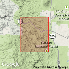
Name applied to basalt that caps Petaca Mesa, northeast of Petaca, [in sec. 5, T. 26 N., R. 9 E., on eastern edge of Las Tablas 7.5-min quadrangle, Rio Arriba Co., Carson National Forest area, central northern NM]. Particularly well exposed to north in Dorado Canyon, [Carson National Forest area, in secs. 29, 32, T. 27 N., R. 9 E.], Las Tablas 7.5-min quadrangle, Rio Arriba Co., central northern NM.
[Additional locality information from USGS historical topographic map collection TopoView, accessed June 8, 2014.]
Source: US geologic names lexicon (USGS Bull. 1200, p. 1140-1141).
For more information, please contact Nancy Stamm, Geologic Names Committee Secretary.
Asterisk (*) indicates published by U.S. Geological Survey authors.
"No current usage" (†) implies that a name has been abandoned or has fallen into disuse. Former usage and, if known, replacement name given in parentheses ( ).
Slash (/) indicates name conflicts with nomenclatural guidelines (CSN, 1933; ACSN, 1961, 1970; NACSN, 1983, 2005, 2021). May be explained within brackets ([ ]).