The National Geologic Map Database is migrating to a new infrastructure. We apologize for any service disruptions during this process.
|
|---|


- Usage in publication:
-
- Donovan formation
- Modifications:
-
- Original reference
- Dominant lithology:
-
- Sandstone
- Shale
- AAPG geologic province:
-
- Eastern Columbia basin
Summary:
Pg. 227 (table 1), 229-235. Consists principally of hard green and gray noncalcareous sandstone, sandy shale, red sandstone, and yellowish calcareous sandstone. Thickness 2,241 to 2,500 feet. Underlies Mowich group; appears to be oldest Jurassic formation in central Oregon; Jurassic sequence lies with high-angle discordance upon a basement of highly folded strata which are in part of Mississippian and [Late] Triassic age. Age of Donovan is Early Jurassic.
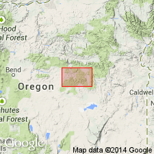
Exposures occupy less than 0.5 sq mi, in secs. 5, 6, 7, and 8, T. 20 S., R. 30 E., 19 mi north of Burns and 10 mi west of Crow Flat Ranger Station. Named from Tim Donovan Ranch, in sec. 7, T. 20 S., R. 30 E., Crook Co., east-central OR.
Source: US geologic names lexicon (USGS Bull. 1200, p. 1140).
For more information, please contact Nancy Stamm, Geologic Names Committee Secretary.
Asterisk (*) indicates published by U.S. Geological Survey authors.
"No current usage" (†) implies that a name has been abandoned or has fallen into disuse. Former usage and, if known, replacement name given in parentheses ( ).
Slash (/) indicates name conflicts with nomenclatural guidelines (CSN, 1933; ACSN, 1961, 1970; NACSN, 1983, 2005, 2021). May be explained within brackets ([ ]).