

- Usage in publication:
-
- Dinwoody formation*
- Modifications:
-
- First used
- Dominant lithology:
-
- Shale
- Limestone
- AAPG geologic province:
-
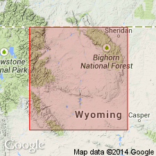
- Wind River basin
- Bighorn basin
Summary:
First used for the upper part of the Embar formation of Darton (1906) in central WY in the Wind River and Bighorn basins. Name suggested by E. Blackwelder for the upper shale part of the Embar where exposed at Dinwoody Canyon along the northeast flank of the Wind River Mountains. At this locality, unit is 200 ft thick and consists of pale-green to white clay (shale) and shaly limestone weathering brown and containing obscure pelecypod shells. Eastward, in the vicinity of Bighorn River canyon near Thermopolis, unit thins and becomes gypsiferous greenish or brownish nonfossiliferous shale. Farther east, beds become increasingly gypsiferous and lithologically similar to red beds of the Chugwater formation. Absence of Dinwoody at the head of No Wood [Nowood] Creek in the southern Bighorn Mountains is attributed to either non-deposition, erosion, or less likely to its lack of recognition owing to its resemblance to the red beds of the Chugwater. Interpretive cross section shows section at Dinwoody canyon and eastward pinchout into shales of the lower Chugwater formation. Columnar sections. Overlies Park City formation (lower part of Embar formation of Darton (1906)) and underlies with slight unconformity red beds of the Chugwater formation. Is assigned to the Triassic [probably based on correlation with Triassic Thaynes limestone and Woodside shale in ID].
Source: GNU records (USGS DDS-6; Denver GNULEX).
- Usage in publication:
-
- Dinwoody formation
- Modifications:
-
- Redescribed
- Age modified
- Areal extent
- Dominant lithology:
-
- Sandstone
- Dolomite
- AAPG geologic province:
-
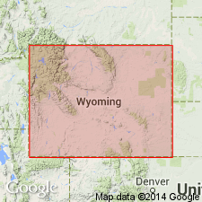
- Wind River basin
Summary:
Considered upper part of Embar formation of Darton (1906) in western Fremont Co, WY in the Wind River basin. Type section not designated but name [probably] taken from exposures at canyon of Dinwoody Lakes [Dinwoody Creek] along the northeast flank of Wind River Mountains. Is distinguished from lower portion (Park City formation) of Embar formation. Redescribed in this region to contain greenish-gray shales with many thin plates of dense, calcareous sandstone, or argillaceous dolomite which weathers brown, tawny, and black. Extended west to Yellowstone province where measured section north and east of Dorwin [Darwin] Peak in Gros Ventre Range shows basal calcareous and cherty sandstone with overlying calcareous shale and clayey dolomite. Is 250 ft thick at Dinwoody Creek but thins to less than 50 ft near Lander; it is 75 to 100 ft thick near Anchor in Owl Creek Mountains and thickens to 210 ft on Crystal Creek in Gros Ventre Range and to 350 ft at north end of Hoback Range. Westward becomes progressively thicker, more calcareous and more fossiliferous and grades into Thaynes and Woodside formations of southeastern ID. Conformable contact with underlying Park City formation and with overlying Chugwater formation. Contains non-diagnostic LINGULAS and pelecypod fragments. Previously considered Triassic now inferred to be either Permian or Early Triassic on the basis of stratigraphic position dating.
Source: GNU records (USGS DDS-6; Denver GNULEX).
- Usage in publication:
-
- Dinwoody formation
- Modifications:
-
- Revised
- AAPG geologic province:
-
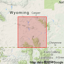
- Green River basin
- Wind River basin
Summary:
Conformably overlies the newly named Ervay tongue--a pink-gray, shaly to sandy limestone--of the Permian Phosphoria formation between the Green Mountains, southeast Fremont Co, WY, Wind River basin, east and south to Red Mountain, Albany Co, WY in Greater Green River basin. Is separable from the Chugwater formation with which it intertongues and underlies by a change of color. Dinwoody is usually gray with alternating dense, fine-grained calcareous sandstone that weathers tan, brown, black. The Chugwater is composed of red shale. Is 10 to 250+ ft thick in the Wind River Mountains. Thins east due to gradational relationship with Chugwater. Measured sections, cross section. Between the Rattlesnake Hills of Natrona Co, Wind River basin east and south to Red Mountain, a variegated sandstone that intertongues and overlies the Freezeout tongue (new) of the Chugwater and underlies main body of the Chugwater, is named Little Medicine tongue of the Dinwoody. Of Triassic age.
Source: GNU records (USGS DDS-6; Denver GNULEX).
- Usage in publication:
-
- Dinwoody formation
- Modifications:
-
- Revised
- AAPG geologic province:
-
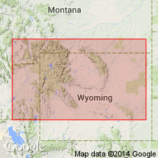
- Wind River basin
- Green River basin
- Bighorn basin
- Yellowstone province
- Montana folded belt
Summary:
Upper boundary revised at Dinwoody Canyon, Fremont Co, WY in the Wind River basin. Restricted to include dominantly silty strata between the Phosphoria limestone and the top of resistant siltstones about halfway toward summit of original [upper limit of] Dinwoody. At this locality, lowering the upper contact reduces the thickness from 200 to 90 ft and now excludes gray shales assigned to the Chugwater or Red Peak Formation (revised). Boundary revision justified because color change from gray to red beds (as originally defined) varies stratigraphically even within a few 100 yards in Dinwoody Canyon. Is abruptly overlain by generally red but locally gray soft shale now considered Red Peak formation. Is subdivided into 3 informally designated units: 1) basal siltstone, present in the Teton, Wyoming and Salt River Ranges, western WY, in the Greater Green River basin and Yellowstone province; 2) LINGULA zone, of mostly silty shale and thin limestone, similarly distributed and also present in the Wind River basin and; 3) CLARAIA zone, of mostly thin and lenticular silty limestone present in all above mentioned provinces and also present in southern Park Co, MT in the Montana folded belt province. Units successively overlap to the east. Stratigraphic relationships, measured sections, and faunal descriptions and plates given. Equivalent to lower half of Woodside formation of Mansfield (1927) in ID. Is Early Triassic in age.
Source: GNU records (USGS DDS-6; Denver GNULEX).
- Usage in publication:
-
- Dinwoody formation*
- Modifications:
-
- Overview
- AAPG geologic province:
-
- Green River basin
Summary:
Name applied to a distinctive unit of alternating thin layers of green-gray, calcareous siltstone and shale, and argillaceous sandy limestone that weather tan or buff gray. Is 650 to 700 ft thick. Is the oldest Triassic formation in quad. It overlies Rex chert member of Phosphoria formation and underlies Woodside redbeds. Mapped (geologic map) in the central-southern and central west parts of quad. in Lincoln Co., WY in the Greater Green River basin. Assigned to the Lower Triassic.
Source: GNU records (USGS DDS-6; Denver GNULEX).
- Usage in publication:
-
- Dinwoody formation*
- Modifications:
-
- Overview
- AAPG geologic province:
-
- Wasatch uplift
Summary:
Name applied to the 1,600 to 1,800 ft of rock between the base of the black shale member of the Thaynes formation and top of the shale member of the Phosphoria formation. Two members (of equal thickness) of Dinwoody mapped (geologic map) on the Georgetown syncline and in the Preuss Range, Caribou Co., ID on the Wasatch uplift. This assemblage of rock has been called Dinwoody since Kummel's work in this area; the rocks were thought by him to more closely resemble the Dinwoody of the Wind River Range, WY than the dark red shale of the Woodside shale of northern UT. Lower member is a thin-bedded to fissile, brown shale and calcareous siltstone that grade upward into thin-bedded limestone. The upper member has the same lithologies, except that shale is less abundant and limestone is more conspicuous. The uppermost limestone bed contains the MEEKOCERAS zone 15 to 20 ft below the top. The most marked lithologic change between the Dinwoody and Thaynes is the black shale of the Thaynes. The base of the black shale is used as the base of the Thaynes. Assigned to the Lower Triassic. Measured section of lower member. Stratigraphic table.
Source: GNU records (USGS DDS-6; Denver GNULEX).
- Usage in publication:
-
- Dinwoody Formation*
- Modifications:
-
- Overview
- AAPG geologic province:
-
- Wasatch uplift
Summary:
Mapped in the northwest, east, and southwest parts of the quad., Caribou Co., ID on the Wasatch uplift. Overlies the cherty shale member at the top of the Phosphoria Formation. Underlies the black limestone member of the Thaynes Formation. Consists of 1,700 to 2,200 ft of limestone, shale, and siltstone. The limestone is gray, fine- to medium-crystalline, thin- to medium-bedded. The shale and siltstone are gray and olive, thin-bedded. Assigned to the Early Triassic.
Source: GNU records (USGS DDS-6; Denver GNULEX).
For more information, please contact Nancy Stamm, Geologic Names Committee Secretary.
Asterisk (*) indicates published by U.S. Geological Survey authors.
"No current usage" (†) implies that a name has been abandoned or has fallen into disuse. Former usage and, if known, replacement name given in parentheses ( ).
Slash (/) indicates name conflicts with nomenclatural guidelines (CSN, 1933; ACSN, 1961, 1970; NACSN, 1983, 2005, 2021). May be explained within brackets ([ ]).