The National Geologic Map Database is migrating to a new infrastructure. We apologize for any service disruptions during this process.
|
|---|


- Usage in publication:
-
- Dinwoody Lake Till*
- Modifications:
-
- Named
- Dominant lithology:
-
- Till
- AAPG geologic province:
-
- Wind River basin
Summary:
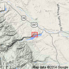
Named for occurrence at Dinwoody Lake, T5N, R5W, Fremont Co., WY in the Wind River basin. No type locality designated. Is the youngest of 3 tills formerly assigned to the Buffalo Till in this area; term Buffalo not used. Disconformably overlies Sacagawea Ridge Till and disconformably underlies Bull Lake Till in 2 measured sections. Is 47 to 63 ft thick in measured section on Sacagawea Ridge, north side of Upper Dinwoody Lake, center sec. 31, T5N, R5W where it is divisible into a lower silt and gravel that is probably an outwash, a middle brown, compact, stony silty sand, a till, and an upper brown, stony clayey silt, a soil. Silt in the middle till was derived from Mesozoic red beds. Some of the striated rocks are limestone. Some boulders derived from the unnamed Tertiary conglomerate. In a second measured section on Cedar Ridge in center sec. 31, T3N, R3W, the till is 60-70 ft thick. Is predominantly pink, silty. Has abundant fresh crystalline and sedimentary rock little of which was derived from the unnamed Tertiary conglomerate suggesting that ice advanced in valley cut into Mesozoic rocks. Outwash terrace associated with this till is 360 ft above the Wind River. Believed to be a pre-Wisconsin, pre-Bull Lake Pleistocene till.
Source: GNU records (USGS DDS-6; Denver GNULEX).
- Usage in publication:
-
- Dinwoody Lake Till*†
- Modifications:
-
- Abandoned
Summary:
Name abandoned; Dinwoody Lake Till formerly thought to be a pre-Bull Lake till is now recognized as the lower till of the Bull Lake glaciation. What was assigned to the Dinwoody Lake: 1.) can be traced into and forms the end moraine of the early stade of the Bull Lake, 2.) is similar in form and surface characteristics to moraines of Bull Lake, 3.) has a buried soil on upper part that is similar to buried soil on Bull Lake elsewhere, 4.) has soil on outwash gravel on 3 terraces 80 to 200 ft above the Wind River that is similar to soils on Bull Lake moraines. These deposits considered pre-Bull Lake now regarded as early Bull Lake.
Source: GNU records (USGS DDS-6; Denver GNULEX).
For more information, please contact Nancy Stamm, Geologic Names Committee Secretary.
Asterisk (*) indicates published by U.S. Geological Survey authors.
"No current usage" (†) implies that a name has been abandoned or has fallen into disuse. Former usage and, if known, replacement name given in parentheses ( ).
Slash (/) indicates name conflicts with nomenclatural guidelines (CSN, 1933; ACSN, 1961, 1970; NACSN, 1983, 2005, 2021). May be explained within brackets ([ ]).