

- Usage in publication:
-
- Dimple Dell Soil*
- Modifications:
-
- Named
- Dominant lithology:
-
- Soil
- AAPG geologic province:
-
- Wasatch uplift
Summary:
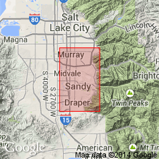
Named after Dimple Dell Road. Only two exposures known in report area. The first, which is designated the type locality and is about 7 ft thick, is in bank of Dry Creek, NW1/4 SE1/4 sec 15, T3S, R1E at altitude 4,770 ft, Salt Lake Co; the second is near mouth of Willow Creek about 1 mi east of Jordan River, N1/2 N1/2 sec 25, T3S, R1W, at altitude of about 4,400 ft, Salt Lake Co. Both localities in UT on the Wasatch uplift. Is developed on pre-Lake Bonneville alluvium. Is overlain by Little Cottonwood Formation (new) of Lake Bonneville Group. Is a Pedalfer that lacks calcareous horizon at both exposures along the mountain front. Westward the soil changes to a Pedocal due to decreasing precipitation. A horizon is lacking, probably due to erosion. Of late Pleistocene age. Correlation chart.
Source: GNU records (USGS DDS-6; Denver GNULEX).
For more information, please contact Nancy Stamm, Geologic Names Committee Secretary.
Asterisk (*) indicates published by U.S. Geological Survey authors.
"No current usage" (†) implies that a name has been abandoned or has fallen into disuse. Former usage and, if known, replacement name given in parentheses ( ).
Slash (/) indicates name conflicts with nomenclatural guidelines (CSN, 1933; ACSN, 1961, 1970; NACSN, 1983, 2005, 2021). May be explained within brackets ([ ]).