

- Usage in publication:
-
- Deweyville Formation
- Modifications:
-
- Mapped 1:250k
- Dominant lithology:
-
- Sand
- Silt
- Clay
- Gravel
- AAPG geologic province:
-
- East Texas basin
- Gulf Coast basin
Summary:
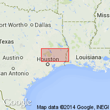
Pamphlet [p. 1]. Deweyville Formation. Sand, silt, and clay, some gravel; includes point bar, natural levee, stream channel, and backswamp deposits at a level only slightly above that of the present floodplain; sand coarser than that in Holocene age alluvium (map unit Qal); gravel mostly along Trinity River, surface characterized by relict meanders of much larger radius of curvature than those of present streams, some scattered pimple mounds, thickness locally more than 50 feet. High level Deweyville (map unit Qd?) surfaces cut in the older (Pleistocene) Beaumont Formation near Liberty are intermediate in position between the Beaumont surface and the level of most Deweyville deposits. Age is considered Holocene or late(?) Pleistocene.
[Mapped along major river drainages throughout map sheet in (alphabetical): Hardin, Harris, Houston, Jasper, Jefferson, Liberty, Madison, Montgomery, Newton, Orange, Polk, San Jacinto, Trinity, Tyler, and Walker Cos., eastern TX.]
Source: Publication.

- Usage in publication:
-
- Deweyville Formation
- Modifications:
-
- Mapped 1:250k
- Dominant lithology:
-
- Sandstone
- Siltstone
- Clay
- Gravel
- AAPG geologic province:
-
- Gulf Coast basin
Summary:
Deweyville Formation. Sand, silt, clay, and gravel in two outcrops where Nueces River leaves Crystal City sheet. [Thickness not stated. Overlies Fleming Formation (Miocene) or Goliad Formation (Pliocene).] Age is Pleistocene; is youngest formal stratigraphic unit in map area.
[Mapped along eastern edge of map sheet, approx. Lat. 28 deg. 15 min. N., Long. 98 deg. 00 min. W., in Live Oak Co., southern TX].
Source: Publication.
- Usage in publication:
-
- Deweyville Formation
- Modifications:
-
- Mapped 1:250k
- Dominant lithology:
-
- Sand
- Silt
- Clay
Summary:
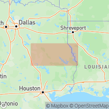
Deweyville Formation. Sand, silt, and clay, some gravel; includes point bar, natural levee, stream channel, and backswamp deposits at a level only slightly higher than present flood plain; sand coarser than in alluvium; surface characterized by relict meaners of much larger radius of curvature than those of present streams, some scattered pimple mounds. Thickness locally more than 50 feet. [Mapped along Sabine River, Newton County, eastern Texas, extreme southeastern corner of map sheet. Older than Holocene age alluvium and younger than Pleistocene age fluviatile terrace deposits.] Age is Quaternary (Pleistocene? and Holocene).
Source: Publication; US geologic names lexicon (USGS Bull. 1350, p. 208).
- Usage in publication:
-
- Deweyville Complex
- Modifications:
-
- Overview
- AAPG geologic province:
-
- Gulf Coast basin
Summary:
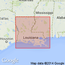
(Quaternary stratigraphic chart). Deweyville Complex. An allostratigraphic unit, defined and correlated by morphologic expression. Consists of one or more alloformations which have yet to be determined. Medial part correlative with upper Pleistocene Peoria Loess and Valley Trains; lower part correlative with uppermost Prairie Complex. Lies above Prairie Complex and older Holocene deltaic and chenier plains. Age is late Quaternary (late Pleistocene to early Holocene).
[Btw. ca. 2000 to 2012 during detailed and reconnaissance mapping (Louisiana Geol. Survey geol. quad. maps, scales 1:24,000, 1:100,000), the Deweyville is referred to as Deweyville Allogroup and subdivided into informal alloformations. In southwestern Louisiana, includes, youngest to oldest, Fredonia, Sandjack, and Merryville alloformations. In southeastern Louisiana, includes, youngest to oldest, Foster Creek, Mitchell Hammock, and Gum Bayou alloformations. Is younger than Prairie Allogroup (middle to late Pleistocene). Age is late Quaternary (late Pleistocene).]
Source: Publication.
- Usage in publication:
-
- Deweyville Allogroup
- Modifications:
-
- Revised
GNC Staff, 2010, [U.S. Geologic Names Committee remarks on allogroups of Louisiana]: U.S. Geological Survey, unpublished Geologic Names Committee note
Summary:
Deweyville Allogroup. Mapped on several 30' x 60' quadrangles by the Louisiana Geol. Survey.
Southwestern Louisiana:
Lake Charles quadrangle (2002): includes, youngest to oldest, Fredonia alloformation, Sandjack alloformation, Merryville alloformation. Younger than Prairie Allogroup. Age is late Quaternary (Pleistocene).
De Ridder quadrangle (2002): includes, youngest to oldest, Fredonia alloformation, Sandjack alloformation, Merryville alloformation. Younger than Prairie Allogroup. Age is late Quaternary (Pleistocene).
Ville Platte quadrangle (2002): includes, youngest to oldest, Sandjack alloformation, Merryville alloformation. Younger than Prairie Allogroup. Age is late Quaternary (Pleistocene).
Crowley quadrangle (2003): includes, youngest to oldest, Sandjack alloformation, Merryville alloformation. Younger than Prairie Allogroup. Age is late Quaternary (Pleistocene).
Southeastern Louisiana:
Amite quadrangle (2009): includes Mitchell Hammock alloformation (named from Mitchell Hammock in Bogalusa 30 x 60 min quadrangle). Younger than Prairie Allogroup. Age is late Quaternary (Pleistocene).
Bogalusa quadrangle (2007): includes, youngest to oldest, Foster Creek alloformation, Mitchell Hammock alloformation, Gum Bayou alloformation. Younger than Prairie Allogroup. Age is late Quaternary (Pleistocene).
Gulfport quadrangle (2004): includes, youngest to oldest, Mitchell Hammock alloformation and Gum Bayou alloformation. Younger than Prairie Allogroup. Age is late Quaternary (Pleistocene).
Source: N.R. Stamm, compiler, US geologic names lexicon, Geolex.
For more information, please contact Nancy Stamm, Geologic Names Committee Secretary.
Asterisk (*) indicates published by U.S. Geological Survey authors.
"No current usage" (†) implies that a name has been abandoned or has fallen into disuse. Former usage and, if known, replacement name given in parentheses ( ).
Slash (/) indicates name conflicts with nomenclatural guidelines (CSN, 1933; ACSN, 1961, 1970; NACSN, 1983, 2005, 2021). May be explained within brackets ([ ]).