The National Geologic Map Database is migrating to a new infrastructure. We apologize for any service disruptions during this process.
|
|---|


- Usage in publication:
-
- Devine Canyon Ash-flow Tuff*
- Modifications:
-
- Named
- Dominant lithology:
-
- Tuff
- AAPG geologic province:
-
- Great Basin province
Summary:
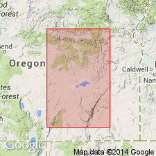
Type locality: exposures in Devine Canyon about 1 km NNE of its confluence with Poison Creek, along HWY 395, 43 deg 44' 05"N, 119 deg W, Harney Co, OR. Consists of densely to moderately welded, crystal-rich, vitric, greenish-gray to light-gray tuff. Thickness is 30 m. Previously included in Danforth, Rattlesnake, and Drewsey Formations and Columbia River Group. Recognized in Harney and Juntura Basins. Overlies unnamed middle(?) and upper Miocene volcaniclastic and sedimentary rocks which overlie Steens Basalt; conformably underlies unnamed tuffaceous sedimentary rocks which underlie Prater Creek Ash-flow Tuff; to northeast in Juntura Basin, underlies Drewsey Formation. Age is late Miocene on basis of 10.0 to 8.5 (mostly 9.3 or 9.2) Ma K-Ar age determinations.
Source: GNU records (USGS DDS-6; Menlo GNULEX).
For more information, please contact Nancy Stamm, Geologic Names Committee Secretary.
Asterisk (*) indicates published by U.S. Geological Survey authors.
"No current usage" (†) implies that a name has been abandoned or has fallen into disuse. Former usage and, if known, replacement name given in parentheses ( ).
Slash (/) indicates name conflicts with nomenclatural guidelines (CSN, 1933; ACSN, 1961, 1970; NACSN, 1983, 2005, 2021). May be explained within brackets ([ ]).