The National Geologic Map Database is migrating to a new infrastructure. We apologize for any service disruptions during this process.
|
|---|


- Usage in publication:
-
- Devils Den limestone
- Modifications:
-
- Original reference
- Dominant lithology:
-
- Limestone
- AAPG geologic province:
-
- Fort Worth syncline
Summary:
Pg. 17. Devils Den limestone. Quite uniform gray or dark bluish hard limestone containing rare crinoids and parts of brachiopods. Thickness in Devils Den, Wise County, [central northern Texas], 50+/- feet, but top is not there visible. Covers west side of Jim Ned Mountains. Seems to be a lenticular mass which thins out and disappears to north. Not found on north side of Sand Flat Range. Separated from underlying Rockhill [Rock Hill] limestone by 140+/- feet of sandstones with intercalated shales, which compose eastern slope of Jim Ned Mountains. "The highest limestones of the section [which would seem to include his Devils Den and Elm Creek limestones] should perhaps be considered as belonging to Canyon division." [Age is Pennsylvanian.]
Source: US geologic names lexicon (USGS Bull. 896, p. 603).
- Usage in publication:
-
- Devils Den limestone
- Modifications:
-
- Revised
- AAPG geologic province:
-
- Fort Worth syncline
Summary:
Pg. 33. Devils Den limestone. Belongs in Graford formation, and because top of Graford cannot be determined in Wise County [central northern Texas], the top of Devils Den limestone is arbitrarily taken as top of Graford formation. To north of Trinity River this limestone is top tongue of Chico Ridge limestone. It is older than Adams Branch limestone. Is overlain by Ventioner beds. [Age is Pennsylvanian.]
Source: US geologic names lexicon (USGS Bull. 896, p. 603).

- Usage in publication:
-
- Devils Den limestone
- Modifications:
-
- Overview
- AAPG geologic province:
-
- Fort Worth syncline
Summary:
Pg. 105, 111, 112. Devils Den limestone in Graford formation. Devils Den limestone is same as Wizard Wells limestone, and latter name is discarded.
Source: US geologic names lexicon (USGS Bull. 896, p. 603).

- Usage in publication:
-
- Devils Den Limestone Member
- Modifications:
-
- Mapped 1:250k
- Dominant lithology:
-
- Limestone
- Sandstone
- AAPG geologic province:
-
- Fort Worth syncline
Summary:
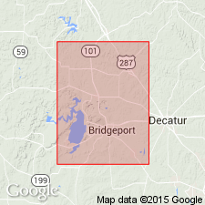
Pamphlet [p. 14-15]. Devils Den Limestone Member of Chico Ridge Limestone of Canyon Group. Medium-gray, yellowish-brown weathering, unevenly and irregularly bedded (up to 1.5 feet thick), fossiliferous limestone. Thickness 3 to 25 feet, thins southward. Is top member of Chico Ridge Limestone; northern limit at West Fork Trinity River [Lake Bridgeport area] where it = and merges with uppermost Chico Ridge Limestone. Lies approximately 150 to 200 feet below northern pinch-out of Winchell Limestone in southern Jack County (see adjacent Wichita Falls-Lawton sheet). Overlies [and in places intertongues with] Jasper Creek Formation; underlies Ventioner Formation; both of Canyon Group. Age is Late Pennsylvanian (Missourian).
[Mapped in Lake Bridgeport area, Jack and Wise Cos., central northern TX; western edge of map sheet. Rocks previously (1967 ed. of map) mapped as Devils Den Limestone Member of Graford Formation. See also adjacent Wichita Falls-Lawton sheet, Texas Geol. Atlas, 1987.]
Source: Publication.
For more information, please contact Nancy Stamm, Geologic Names Committee Secretary.
Asterisk (*) indicates published by U.S. Geological Survey authors.
"No current usage" (†) implies that a name has been abandoned or has fallen into disuse. Former usage and, if known, replacement name given in parentheses ( ).
Slash (/) indicates name conflicts with nomenclatural guidelines (CSN, 1933; ACSN, 1961, 1970; NACSN, 1983, 2005, 2021). May be explained within brackets ([ ]).